Misadventures in Nidderdale

The landscape glimpsed through the skeletons of summer's cow parsley.
The landscape glimpsed through the skeletons of summer’s cow parsley.

Yesterday’s outing was a gem.  We walked in bright late summer sunshine as the trees began changing colour for Autumn.  Great views over Nidderdale and a few interesting animal encounters added pleasure to the day.  And best of all was the chance to tease Our Leader For The Day – let’s call her Ms. X, to spare her blushes.  Within 10 minutes of starting, she’d taken us off-route.  A landowner called us off the steep hillside that she was already scaling.  ‘It’s private land – but in any case it doesn’t lead anywhere.’  That wasn’t surprising.  There was no path.

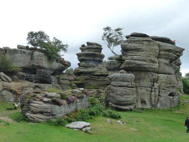
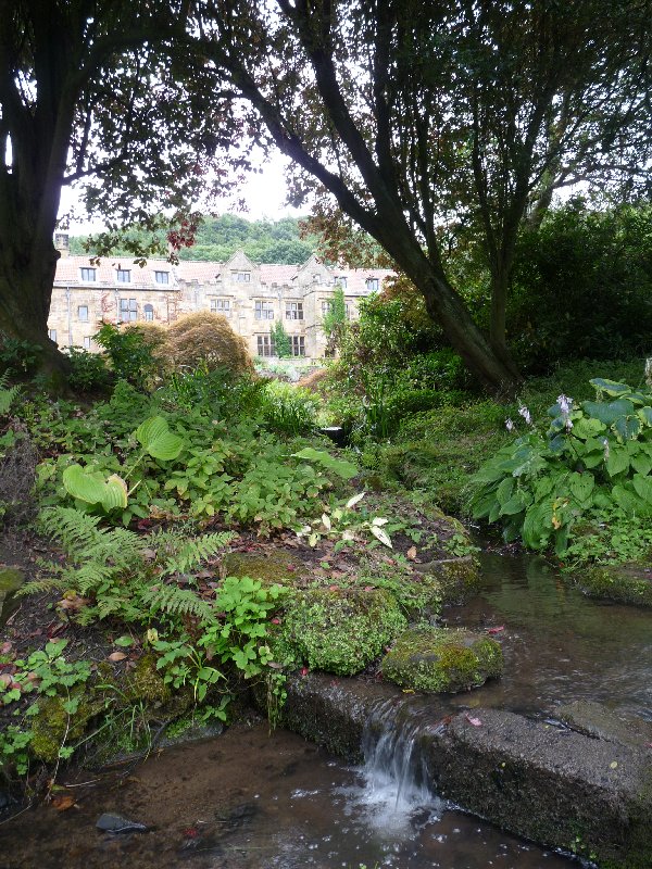
Never mind.  We were enjoying fine panoramas, and a path that led onwards and upwards into ancient woodlands where large rocky outcrops showed us we weren’t at all far from Brimham Rocks.  The paths round here were the stamping ground of lay brothers from Fountains Abbey who lived and worked in this area.  They would have appreciated the fresh water springs, one of which has a carved stone alongside: ‘Adam’s Ale’, it says.

Here's fresh water, aka Adam's ale
Here’s fresh water, aka Adam’s ale

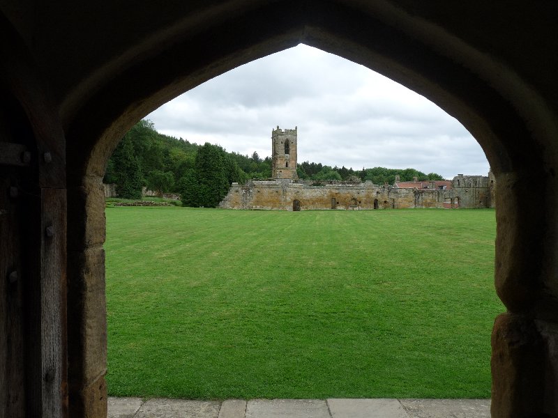
The monks of Fountains Abbey had complete control of the Hartwith area from 1180 until the dissolution of the monasteries.  It was home for their sheep; a source of wood; and animal fodder; and stone from the glacially deposited millstone grit , which was used to make mill-stones (‘quern-stones’).  It was here too that the Abbot of Fountains Abbey had his own private hunting park.

After that we were on National Trust land, and the outer-reaches of the Brimham Rocks estate.  Here, the landscape changes for a while to austere and fairly barren moorland.  But it was easy walking, and we were entertained by a fine herd of long-snouted ginger Tamworth pigs corralled on the edge of the moor.  They were vocal, curious, and keen to eat my gaiters.

Two nosey pigs.
Two nosey pigs.

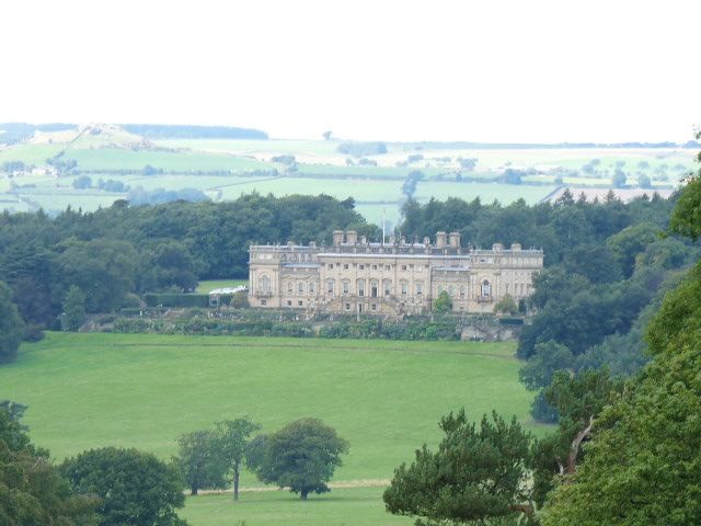
Then we got lost again.  Ms. X led us through impenetrable bracken, at the edge of which she promised us a stile.  There wasn’t one.  We returned through the impenetrable bracken, and found the correct – and easy – path.  We passed the handsome Jacobean Brimham Lodge, built on the site of the Abbot’s Hunting Lodge.  Those Abbots knew how to choose a good view.

This was a day of many stiles.

Now we were onto areas of pasture-land.  These fields have been progressively cleared in the years since the Dissolution of the Monasteries by the landowners who took over monastic lands.  We picnicked in a field by a little-used track.  Two of us spread ourselves out on the little-used track.  We opened our sandwiches.  And a large tractor advanced on us – down the little-used track.

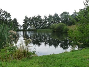
Throughout the afternoon, we passed several ponds, probably originally fish ponds for – yes, you’ll have guessed – Fountains Abbey.  Ducks escorted us along the roads, geese protested at our presence: it was all very bucolic.

At last, we reached ancient woodland – Old Spring Woods is known to have existed in prehistoric times.  Remains of stone enclosure suggest that at one time, the area was used for grazing stock, but later, hunting became more important.  And it was here that Ms. X led us astray for the last time.  At the bottom of a long descent she insisted she’d gone wrong.  Up the hill we trailed, and all of us had a go at re-interpreting the map in our own way.  By popular vote, we all traipsed down the hill again, and found the path we’d needed all along, just there, beyond the woodland gate.  And we were nearly home and dry.

But our day wasn’t over yet.  Ms. X suggested finishing off the afternoon at an ice cream parlour a couple of miles along the road.  It wasn’t her fault that the signs to it on the main road all read ‘Open’.  It wasn’t her fault that there was a long and bumpy farm drive down to the café .  And it wasn’t her fault that when we got there, the café turned out to be shut.  But we blamed her of course, just as we blamed her for every mishap along the way, even though we all had a hand in reading the map.

She knows we don’t mean it.  We’d had a Grand Day Out.  We’d had a good work-out, a scenic walk full of interest, a fine day out with friends, and a chance to tease Ms. X unmercifully.  Thank you, Ms X.

A view across Nidderdale near the end of our journey

Druids’ folly

It was all a bit competitive being a landowner in 18th and 19th century North Yorkshire.  You wanted the fine house.  You wanted the spacious and gracious gardens, landscaped to be ‘picturesque’: nature celebrated but tamed, rather than strictly-organised and geometric, as in much of the rest of Europe.  And you wanted the Folly.  You were looking for an extravagant yet  decorative building, that displayed to the world your appreciation of classical, Egyptian or Gothic architecture.  It was without purpose, it was eccentric, and it was a fake.

But that was entirely the point.  A folly was for fun.  It might complement the view.  It might make a destination for a stroll for your family and guests.  It might even be a picnic spot for a wider public looking then, as now, for something nice to do on a sunny Sunday afternoon.

Today, the ‘wider public’ was the Ripon U3A (University of the Third Age) walking group.  It was not however, a sunny Sunday, but a dank and drizzly Friday.  Our path took us through Colsterdale up the now dismantled track of the narrow-gauge railway built in 1902 to transport materials used in the construction of  nearby Leighton reservoir.  During WW1, the railway’s destination, Breary Banks, became a training ground for the volunteer soldiers of Leeds Pals.  We tramped up the hill as those soldiers-in-training must have done: more suitably clad, certainly, and just as capable of sending the sheep running for cover in the bracken.

Sheep inspecting the troops.

Then we were into woods, and along another path, and found ourselves…… in a clearing, with an oval of standing stones, some of them fashioned into doorways or caves, but all of them contributing to a sort of over-furnished Stonehenge.  It’s not North Yorkshire’s answer to Stonehenge however, but William Danby’s folly.  William Danby was the owner of the Swinton Estate, on whose lands we were standing.  That is, both William Senior, who lived in the latter half of the 18th century, and William Junior, his son.  Which of them built the folly is a bit of a mystery.  Both of them were probably intrigued by the Druids.  Poets and antiquarians at the time saw them as England’s earliest men of learning, the guardians of early belief-systems, and the first English patriots.  Some say too that this ‘ancient temple’ was devised as a means of providing employment for men returning from soldiering in the Napoleonic Wars.  There’s a story that there was a seven-year job on offer to anyone who would live as a hermit on the site.  It’s thought that nobody stayed the course.

Druids Temple
Druids Temple

We explored the stones and caves, standing atmospherically on this slightly misty day at the edge of a suitably gloomy forest.

Another view from the temple.

And then we went for coffee and cake at the Bivouac, a marvellously isolated and quirky cafe on a site -with-yurts for serious glampers.  Definitely worth a detour.  Suitably fortified, we finished our circular walk, and were back at home in time for a late lunch.  A healthy walk, a couple of history lessons, a great coffee-stop.  What better way to start the weekend?

Here be druids.
Here be druids.

I should mention that these photos give quite the wrong impression of our not-at-all miserable day.  They were actually taken earlier this week, when the weather was really gloomy, and our French friends were still here.

The Whitby jet-set

We’ve just had good friends from Laroque staying for the week.  We’ve been obliged to polish up our French, which turned out not to be as hard as we’d feared.  And we’ve been doing our best to show-case Yorkshire.  We didn’t expect that to be hard, and it wasn’t.  But we had fun exploring links between our two home areas, something I’ve talked about before here.  Easy enough when you’re walking in the hilly limestone scenery of the Dales, or discussing breeds of sheep, or our former textile and mining industries,  or bumbling along single-track roads in the country, with no villages in sight.

But it would be stretching a point to find a meeting point between the land-locked Ariège, and the East Yorkshire coast, surely?  Well, as it happens, no.  We had a day exploring the coast near Whitby: and I remembered that during the 1800s, Whitby and parts of the Ariège, Laroque d’Olmes included, had a thriving industry in common.  Jet.

19th century mourning jewellery.  Wikimedia Commons.
19th century mourning jewellery. Wikimedia Commons.

Back in the mid 19th century, the fashionable French and English alike couldn’t get enough of the gleaming, richly black fossilised wood that came out of local cliffs (Whitby) and river beds (Ariège) to be transformed by local workers into brooches, earrings and lockets.  In its hey-day, the industry employed thousands of people engaged in finding and extracting the mineral, carving and polishing it.  Queen Victoria ensured its continued popularity in England by wearing jet as mourning jewellery when her beloved Prince Albert died.

We found no jet.  So Wikimedia Commons had to help me out.
We found no jet. So Wikimedia Commons had to help me out.

Its decline  as a fashion item matched the decline of readily available sources of the material.  Somehow, by 1900, jet had lost its allure, and both areas lost an important source of employment.  Jet in the Ariège is consigned to history books and museums.  In Whitby, however, there’s something of a revival, and there  are once more a few shops selling costume jewellery and other items made of jet.

We never found a single piece, but not for want of trying. Instead, we had a more traditional day at the sea.  We ate large plates of fish and chips.  We seagull-watched.  We paddled on the beach and investigated rock pools.  And we ended the day at the higgledy-piggledy and charming settlement of Runswick Bay, clambering up and down the cobbled streets and admiring the quaint cottages with their views across the bay.

Our départ réel from Harewood House.

Wednesday, August 20th.  The morning air was chilly, just a little damp and drippy.  Flowers in the borders hung their heads, their petals shabby and tired.  Autumn has arrived.  It does seem a little previous.

'All is safely gathered in/ Ere the winter storms begin'
‘All is safely gathered in/
Ere the winter storms begin’

All the more reason to get out and about, before the days really close in.  Ripon Ramblers chose to go to Harewood.

You’ll perhaps have seen Harewood House  on TV recently, as that’s where the Tour de France really started from this year, after the Départ fictif  from Leeds.* Half way between Leeds and Harrogate, it’s a playground for both towns, with its fine Adam-designed stately home, and extensive grounds designed by Capability Brown. At the time, the 1750s,  investment in the slave trade brought immense wealth to the Lascelles family.  Their descendents, the Earl and Countess of Harewood live in these fine surroundings built two and a half centuries ago.  This stately home is regarded as being among the finest in Britain and is for the most part open to the public.

Our walk took us on a circular path that began outside the grounds, over farmland and with views across the Wharfe Valley.  The route across the cow pastures was a bit of a puzzle.  Weren’t those mango stones beneath our feet?  And melon seeds? And even squashed tomatoes?  The smell of rotting fruit wasn’t what we looked for on a country walk.  Finally a young woman from a nearby stables helped us out.  A local supermarket regularly dumps its surplus fruit at this farm for the cattle to enjoy.  Four tons of fruit seemed to us to be remarkably poor stock control on the shop’s part, and we couldn’t help wondering what the cows’ insides made of this exotic diet.

Cow on a mango-hunt.

Far more enjoyable were the autumn fruits that lined our route for much of the day.  We gathered blackberries every time we felt hungry or thirsty.  We enjoyed the sight of haws turning red, elderberries turning black, and prickly chestnuts swelling and fattening on the trees.

We completed our upward yomp, and walked along the ridge which offered a fine panorama across to the Crimple Valley and Harrogate beyond, to Almscliffe Crag, and even Ilkley Moor.  Clouds in a dramatically cloudy sky were unloosing light rain into the nearby plain, and the breeze soon pushed the showers our way…..

Look carefully.  You'll see rain falling in the plain  below.  But not on us.
Look carefully. You’ll see rain falling in the plain below. But not on us.

….and then pushed them on again, so that we could enjoy a rain-free lunchtime picnic with all that view before us.

Lunchtime view over the Crimple Valley.

After lunch, we were in the grounds of Harewood.  Not the formal grounds near the house itself, but areas of woodland, pasture, lakes, deer park and farmland.  And  in the distance we spotted a fake Dales village, only built in 1998.  This is  Emmerdale, used in filming the long-running soap of the same name.  No filming that day, so we were soon on our way, hurrying now before the rain, promised for mid-afternoon, settled in to spoil our walk.  We made it – just.

Our best view of Harewood House came at the end of our walk.

* The ‘départ réel’ of the Tour de France from Harewood signified the true beginning of the race.  City centre Leeds was no place for cyclists to jockey for position, so riders just tootled out to Harewood on the ‘départ fictif’.  Then the action started.

Brimham Rocks

We’ve had quite a weekend.  Our vaguely organised daily lives, with plenty of chances to stand and stare, or at least sit down with a cup of coffee and the paper have been shot to pieces by the arrival, for two days only, of our twin nine-year old grandsons, Alex and Ben.

We had a busy Saturday, full of pancakes, playgrounds, and Ripon’s Prison and Police Museum (recommended).  But the highlight of the day was Brimham Rocks.P1150790

It’s an extraordinary place.  There, slap-bang in the middle of the rolling and verdant Yorkshire Dales, is a 30 acre fantastical landscape.  Dry-stone walled fields and charming villages are suddenly replaced by an odd collection of weird and wonderful shaped rocks.  Brimham Rocks.  These are formed from millstone grit: glaciation, wind and rain have eroded them into extraordinary formations, pierced by holes, balancing apparently precariously, or stacked into tottering towers.  Geologists study them, rock climbers scramble up them, but above all, families come to let their children become impromptu explorers, mountaineers and adventurers of every kind.

We’ve only chosen quiet times to visit here in the past, but with Alex and Ben, we had no choice,  We wanted to take them there, so a brisk and breezy Saturday slap-bang in the middle of the school holidays it was. The car park was overflowing .  Oh dear.

But it was fine.  The space is big enough to provide room for all.  And it was fun to be amongst children from the smallest toddler to the tallest and lankiest of teenagers, all having an equally good time: all exploring, all testing themselves physically, weaving their own adventures.

Alex and Ben take a pause at Brimham Rocks

And besides, we didn’t come home empty-handed.  August is bilberry season.  Alex and Ben, particularly Ben, rose to the challenge of stripping the small and rather hidden fruits, becoming ever more purple as time passed.  Teeth turned blue, hands indelibly stained, fingernails beyond help from any nailbrush: it was so good to see my grandchildren discovering the pleasures of food-for-free.  Bilberry pancakes for Sunday breakfast then…..


Industrial life, Nidderdale style

Gateway to our tour of the mines.

Take a walk through much of rural Nidderdale in North Yorkshire, and almost the only sign of human endeavour that you’ll see is connected with agriculture.  Go out into this lightly-populated area, with its apparently nearly barren hillsides, and you’re only likely to meet sheep, with the occasional field of cattle.

Yesterday, we went to  Greenhow.  It’s a charming, pretty village more noted these days for being the highest village in Yorkshire: a whole 400 metres or so above sea level.  It used to be an industrial power-house.  It was here and in the surrounding area that villagers used to mine for lead.  And the signs of this ancient industry are still here.  We set off on a walk across moorland and valley to investigate.

It’s thought that the Romans were the first to mine lead in the area, and by 1225, the abbots of Fountains and Byland Abbeys were apparently squabbling(!) over rights to mine at nearby ‘Caldestones’.  This valuable commodity  was transported over, for the time, immense distances.  In 1365 for instance, a consignment was sent to the south of England, to Windsor: ‘Two wagons each with ten oxen carrying 24 fothers* of the said lead from Caldstanes in Nidderdale in the county of York by high and rocky mountains and by muddy roads to Boroughbridge’.  At which point, the journey perhaps continued on water.  Indeed, lead was exported as far afield as Antwerp, Bordeaux and Danzig.

The beginnings of a long journey for that now-smelted lead.

Well, we were on those ‘high and muddy mountains‘, but they didn’t cause us too much trouble.  Comfortable walking boots and a bright sunny day probably helped us on our way.  What we did see were warrens of carefully constructed and stone-lined tunnels leading to the ancient and now fully-exploited lead seams.  We saw, in the small streams now coursing along some of them, how water became a real problem to the miners of those seams.  Horse tramways hauled lead , which was smelted on site, off to what passed for major roads at the time.  It was obvious to us how very difficult transport must be in this up-hill-and-down-dale area, which even than was not highly populated, with poor transport infra-structure, and unsophisticated wooden carts to carry the goods.  Ancient spoil-heaps from now-exhausted seams litter the area.

An old lead-works, spoil heaps, a river and a perfect picnic spot.

And at the end of our journey, we strode up to Coldstones Cut.  This is a fine art work, a vantage point from which to see a vast panorama of the Nidderdale Area of Outstanding Natural Beauty and beyond, as well as the last working quarry in the area.  These days, it’s all about aggregates and asphalt, but the quarry has a long history of providing lead, then limestone as well as other materials.  Andrew Sabin‘s viewing area is part streetscape, part brutal stone-block construction.  It’s a magnificent intermediary between an immense and busy industrial landscape, and the gentler and even vaster rural one in which it’s situated.


* An old English measurement equalling about 19.5 hundredweight.

A solitary and ascetic life

Mount Grace Priory viewed from the cloisters

As you travel round North Yorkshire, you quickly become aware of its Christian heritage, and realise how many abbeys and monasteries there were, from a variety of religious foundations, for Henry VIII to get his teeth into once he’d laid his plans for the Dissolution of the Monasteries in the 1530s.

Fountains Abbey, as I mentioned in a recent post, is just down the road, and Jervaulx and Rievaulx aren’t far away: there are at least a dozen more.  And each of them is ruined, left waste after Henry VIII pensioned off or martyred the abbots, priors, monks and lay brothers, and all the equivalent females too.

Today we visited Mount Grace Priory near Osmotherly.  We’re accustomed to making a tour, when we visit these religious sites, of chapels, refectories, kitchens, cloisters – places where monks or nuns and lay brothers or sisters gathered together in spiritual or physical work for the benefit of their own and perhaps the wider community.

Not so at Mount Grace.  This community was a Carthusian foundation.  The Carthusians developed their order as a reaction to the lax conditions tolerated by many other religious orders at the time – the late 11th century.  Initially centred on Chartreuse near Grenoble, the order founded religious houses throughout Europe, reaching Mount Grace in the later 14th century.

The simple, unadorned architecture of the priory.

Seven years is the time it took to become a full Carthusian monk.  Seven years in which to decide whether the full religious life of solitary prayer, contemplation and work was for you.  Seven years in which you would only ever see your fellow monks on a Sunday, at Chapter meeting.  For the rest of the time you lived completely alone in your own little house which gave onto the large Great Cloister.  Here you had a room in which to sleep and pray at the proper appointed times, a small living area with a large hearth, and upstairs, a room where you would work.  Perhaps you would weave, or write out or illustrate manuscripts.  Sometimes you would grow vegetables or fruit and herbs in your little patch of garden. You might walk or meditate in your very own mini-cloister.  Even mealtimes were solitary.  Your (vegetarian) food for your twice-daily meals would be pushed through a space in the wall by a lay brother whom you never saw. Bedtime was 6.00 p.m. and there were two extended times of prayer through the night. What you also had, though, extraordinary for medieval times, was a privy regularly flushed from springs in the area, and cold piped running water.


The monastery site includes a prison to confine brothers who became disobedient. At a time when mental illness was little understood, surely some must have reacted badly to this life of extreme solitude, and become ‘problems’?  Any yet there were always far more men wanting one of the 25 places at this austerely- run yet comfortable priory than could be accommodated.

The lay brothers who did much of the ‘housekeeping’ led similarly solitary lives, as far as their working day permitted.  They farmed, made domestic pottery ware, looked after working animals, and the fish ponds: fish were apparently sometimes served as part of a vegetarian diet.

One of the several fishponds.

Naturally women were never permitted on site.  Both male and female pilgrims would stay in what is now the Manor House from time to time, as monasteries have always had an obligation to offer shelter to travellers.

Since the Dissolution, the priory and its surroundings have been abandoned and fallen into ruin.  The surrounding farmland was sold off, and the Manor House was converted and adapted for family life at various times in both the 17th and 19th centuries.  The refitting of the house in the  popular Arts and Crafts style at the turn of the 20th century deserves a post of its own.

Mount Grace is a lovely site. Malcolm and I were happy to visit it together, to have the chance to talk to informative and enthusiastic staff, and to wander around at our leisure.  Living there for an entire adult life, under strict Carthusian rule?  Not a chance.

This is the Manor House as it appears today, viewed from the garden and fishpond.
This is the Manor House as it appears today, viewed from the garden and fishponds.

Nature at Nosterfield

View from a hide at Nosterfield.

Not far from here, only about two miles as the crow flies, is a nature reserve, Nosterfield Local Nature Reserve.  And ‘as the crow flies’ is an appropriate way to measure the journey there, because above all else, it’s a bird reserve.  Even more than that, it’s a wetland reserve.


Evening at Nosterfield.


Until the 1990s, this was a landscape quarried for its sand and gravel, exposing the underlying limestone and fluctuating water courses.  Even as the land was worked birds flocked here in search of insects.  Once the quarries closed, the land proved unsuitable for agriculture: the intermittent flooding saw to that.

Wildlife took the site over.  Wading birds adore the muddy margins and insect-rich grasses.  Natives such as lapwing and curlew breed here, whilst many other species, such as sandpipers and godwit drop in as they migrate.  Dozens of other species of bird make this their home, holiday destination, or stop-over site.  At the moment, harvest time, Canada geese are exploiting the riches of the harvest.  If they’re not noisily camping out in the wheat field just behind our house, you can be sure they’ll be at Nosterfield.


Since 1996, the area has been a nature reserve.  A group of local naturalists succeeded in buying the site, having formed the Lower Ure Conservation Trust. They manage the site to exploit its already abundant resources.  The fluctuating water levels – up to three metres a year  variation is not unknown – means that there is everything from muddy shallows to small shallow pools to deeper sheets of water.  There’s something for everyone, if you’re a bird who likes water.  Or even if you’re a bird such as a wagtail, linnet or twite, who doesn’t.

The site supports a huge variety of wild flowers and grasses.  That means there are insects, butterflies such as common blue, brimstone, wall brown and white-letter hairstreaks and moths too.  There are rabbits and hares: while voles and shrews are preyed on by kestrels and barn owls. Summer-grazing cattle and sheep assist in managing the landscape: one way or another, this is a success story.


A busy evening at Nosterfield


We simply aren’t birders.  Not yet.  But this reserve is doing much to help change all that.  There is a series of well-managed hides, and best of all, a comfortable  unstaffed information centre, with piles of illustrated leaflets and books to help us identify what we’ve seen.  It’s a serene and beautiful place to spend a quiet couple of hours watching the soap opera of bird life unfold, as they feed, raise young, quarrel, swim and wheel about above.  We  love visiting at different times of day, and look forward to coming throughout the seasons to see how the local bird population changes.  By this time next year, we may be able to identify much of what we see.  Maybe.


Sunset at Nosterfield

The Old Grange

Here's the Old Grange, as it was in May, with the wisteria out.
Here’s the Old Grange, as it was in May, with the wisteria out.

As we’ve been four months back in England, it’s perhaps time to introduce our home, which answers to the name of ‘The Old Grange’.  I’ve already mentioned that it’s in part of an older building which forms part of a large, mainly Georgian house.  To understand how it came to be built, we’ll have to pay a quick visit to UNESCO World Heritage site, Fountains Abbey and Studley Royal, some 5 miles from us as the crow flies.

The nave of the now ruined Fountains Abbey

Back in 1132, there was no Abbey.  But there were 13 monks anxious to build one.  These particular men had joined holy orders in order to live a simple, strict and holy life, and were dismayed by the lax conditions they found in the Benedictine order they had joined.  The Archbishop of York offered them his protection, and the gift of some land near Ripon on the banks of the River Skell.  This area now is a fertile place, with pastureland, woods, stone for quarrying, and the waters of the Skell.  Back then, it was a hostile, overgrown and thoroughly unpromising environment.  The monks joined the Cistercian order which they felt offered the structure and discipline they sought, and strove to emulate the lifestyle promoted by its founder Bernard of Clairvaux.  A tough life of manual labour, self-sufficiency, and prayerful spirituality was the order of the day.

A view of Fountains Abbey: Wikimedia Commons

To cut a very long  story short – one which I will tell in a future post, because it’s a fascinating one – the Abbey the monks built prospered, to the extent that it became one of the largest, most successful and wealthy monasteries in the whole of Europe.  When Henry VIII dissolved the monasteries in the 1530s, the buildings and lands belonging to Fountains Abbey sold for over £1,000,000 – unimaginable wealth at the time: the monastery had acquired land over much of Yorkshire and Lancashire.  The simple life of those early monks had changed over the years. The monks themselves devoted more of their time to their spiritual life, with prayerful ritual being an important part of their routine.  The day-to-day work, mainly with sheep and cattle and all the other work associated with farming, both at Fountains itself and at all the other sites, was done by the so-called ‘lay brothers’.  Less educated, they had far fewer spiritual obligations.   And they lived communally in ‘granges’.

All those older buildings you’ll see as you travel around this part of the world, which include ‘grange’ as part of their name owe their existence to the fact that once they housed those lay brothers, mainly from Fountains Abbey.  The room where we sleep once formed part of the dormitory where the men working at our ‘old grange’ once slept.

In truth, it’s hard to believe.  We live in a stone building of traditional design, but with all mod cons.  One of the few signs of the building’s age is the huge fireplace on the ground floor which is now simply an alcove, though we gather it wouldn’t take much to reveal the old spit mechanism.  We have only one room downstairs.  The other spaces, which we have no access to, are now, as then, workspaces and storage areas.

Upstairs, where the bulk of our living space is, was once a single room, as long as the building itself.  In Victorian times, the owners of the larger property which had been built onto the original Old Grange in Georgian times, decided to break up the space into a number of rooms, to make it convenient to use as servants’ quarters.  And this is where we now live.

We find all this thoroughly exciting.  We enjoy noticing other granges as we explore Yorkshire, and we appreciate the connection that we now know we have with Fountains Abbey, a wonderfully beautiful site, whose history has touched the area for so many many miles around.

The Old Grange seen from the walled garden which most certainly was unknown to those lay brothers.
The Old Grange – the top floor dormitory – seen from the walled garden which most certainly was unknown to those lay brothers.

The bells of Saint Wilfrid

Ripon Cathedral: image courtesy of Wikimedia Commons.

Last week, I got the chance to climb the bell tower at Ripon Cathedral.  How could I refuse?  Hearing the full peal of bells joyously announcing Sunday worship, and at other times too,  is one of the privileges of being near Ripon.

Bell ropes ready for action.

It was Wednesday evening.  That’s when the team of ringers always meet to practise and learn new changes.  I knew bells were rather heavy things, and imagined that tugging on the bell-ropes to make them chime must be a young person’s hobby – preferably a burly, muscular young person.  But no.  Bell-ringers are young, old, male, female, slim and rangy, tall and chunky, small and wiry.  All that’s needed is an enthusiasm for this particularly British pursuit.

Getting started.
Getting started.

It was a fine thing to watch every member of the team as they got each bell going.  That did look hard work.  Holding the rope high above their heads, each ringer tugged to bring it low down, again and again, till the bell had acquired its own satisfying momentum: till indeed, it was turning so far that the bell reached the top of its 360 degree swing, paused momentarily, and could be controlled.  Each bell sounds a different note in the scale, with each ringer sounding his or her bell in harmony with the rest.

Keeping the rhythm going.

There may have been bells in Ripon cathedral since the 13th century.  Over the centuries, bells have been replaced or recast.  The bell tower itself has been refurbished several times to replace ancient, beetle-infested timbers.  By the early 20th century, the cathedral at Ripon acknowledged that its bells were no longer really doing a great job, so in 1932, ten of them were recast by John Taylor and Co. of Loughborough – one of only two bell foundries left in the country.  Three more bells were added in 2007/8.  At the same time as the main recasting, the bell tower was strengthened with steel and concrete.  Since the heaviest bell (and it’s one of a team of 13) weighs in at  one and a quarter tons, a good strong and safe bell tower  seems essential.

Bell in the belfry, almost fully turned.

It was a wonderful thing to watch the ringers working in rhythmic harmony (pull, pause, pause, pull), but what made the evening even more special was the opportunity to climb the bell tower itself.  We had to put on thick ear protectors.  Then we climbed the twisting narrow stone stairs, with almost impossibly far-apart treads, to find ourselves on what amounted to a walkway around the majestically swinging, harmoniously clanging quite enormous bells.  We felt the tower shudder and sway and assumed it was our own fantasy.  No, apparently it really does move with the momentum of all those bells.  Despite the ear protectors, our ears felt sore from the auditory assault. Eyes and ears feasted on those bells swinging, sounding and reverberating.

A  harmony of bells.
A harmony of bells.

Reluctantly, we ventured down the stairway once more.  The ringers were well into their rhythm now, guided by the somewhat arcane instructions of their leader, which meant absolutely nothing to us.  But I can see the attraction of being part of such a well structured and purposeful team, using skills that have changed little over the centuries.  I can understand why they like occasionally to give themselves challenges such as ringing a full three-hour peal, why they welcome visiting bell-ringers, why they enjoy the chance themselves to ring different bells in different churches.  And why, apparently, at the end of a hard-working practice, they like nothing more than to get down to the local pub and sink a well-earned pint.

Thanks, North Stainley Women’s Institute, for organising this visit, and to the bellringers of the cathedral for allowing us a glimpse of their Wednesday evening practice.