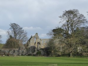
I first walked from Jervaulx to Jervaulx last April, and wrote about it here. However, I failed to lead my fellow ramblers along the same route later that month as I’d said I would, because it rained…. and rained. I’d promised them the walk though, and today was the day: bright, sunny, blustery – a perfect winter hike. Except for one thing. Those floods that have dominated British news this winter are still making their presence felt.
The ruins of Jervaulx.
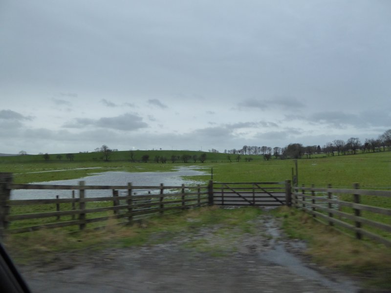
Our route today didn’t take us through pastureland. Sheep aren’t very good at being knee-deep in mud. It took us through soggy fields, and past lake after lake after lake: waters that simply were not there last time I took this route. It was all very pretty. Less pretty was the scene at stiles. Look at us skidding and sliding, trying to pick the shallower puddles as we waited out turn to get from one field to another.
We’re British though, always plucky in adversity. We soldiered on, sometimes a little weary of heaving mud-crusted boots along sticky, sludgy paths. But nobody fell over, nobody lost their sandwiches in the mud. Everybody enjoyed those vistas over the Dales, the starkly beautiful skeletal outlines of winter trees, the blue skies, dappled with characterful cloud. Were we glad to have made the effort? Well, I was, and I think my steadfast and dependable companions were too.
I’m at university this week. The University of Blogging. This seat of learning, which has no rector, no library and confers no degrees, runs a programme regularly hosted by WordPress,and aims to bring together people who from all over the world, keen to hone their writing and presentation skills, and to help each other to Write a Better Blog.
Today’s assignment:
Publish a post you’d like your ideal audience member to read.
I’ve chosen to write for one of you. We haven’t met. We don’t live on the same continent. But we’re ‘blogging friends’ who enjoy one another’s posts and often say so. You say you like the posts I write about walking in the Yorkshire Dales. I like the posts in which you too describe your walks, often more extensive than mine, taking place over several days. You stride beside me – virtually of course – as I tramp along the leaf mould paths of a dappled English woodland. I stop to gaze across the green and undulating hills at the lattice work of ancient fields, divided by drystone walls, and share the view with you courtesy of my camera.
Except… I haven’t. Not lately. Those floods I wrote about a couple of weeks ago are an ever-present danger to some. And even for those who haven’t had flooded homes to contend with, the weekly rhythm has changed. Walking is quite simply not on. The other day, fed up with the lack of exercise, I took myself off to walk along country roads instead. I’d not been going ten minutes when I met a deep trough as wide as the road, as deep as my ankles, and as long as… well, I don’t know. It went beyond the next bend, anyhow, and I went home. The fields are home to seagulls who bob about on the choppy waters. The paths are streams. The streams are rivers. And the rivers are seas.
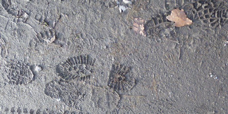
Quiz question. Which is the path, and which the brook?
A path through the woods.
Brian can’t wait to get home.
i) Quiz question: which is the path, and which the brook?
ii) This, I’m afraid, is a path.
iii) Brian-from-Bolton simply can’t stand getting his paws muddy. He’s urging me home – NOW.
But I’m keen to get out and about again as soon as I can. And I hope you’ll come with me, in a virtual sort of way, when I report back.
Yesterday was the day when Malcolm was to have done his first ‘proper’ walk since his operation. But life got in the way, and at the last minute, he had to wait in for a workman. I went anyway, because I was ‘recce-ing’ the route ahead of leading the Ramblers on the same route in 10 days or so: and it’s a busy 10 days.
The route I was checking was a walk full of only charm and delight:
– because, unusually, I could get from door to door (not that walks have doors) courtesy of the bus that passes the end of the road. There are only 3 buses a day, mind you, so some planning is necessary.
– because it follows paths in the gentle sweeping valley of Wensleydale: a tranquil, lush and gently wooded area.
– because the walk begins and ends at one of Yorkshire’s ruined Cistercian abbeys – Jervaulx. It’s even more ruined than Fountains and Rievaulx, but it’s a peaceful place to meander through; to sit quietly; or to explore for flowers clinging to ancient architraves, or topping off columns which no longer have any roof to support.
– because the path I took leads through English parkland which at this time of year is home not only to sheep, but to their young lambs, busily feeding, playing ‘I’m the king of the castle’, and having lamb-races, before cuddling up with mum for another little sleep.
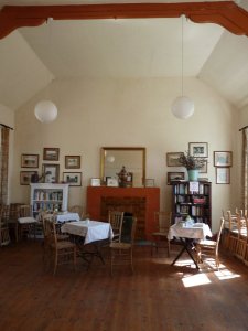
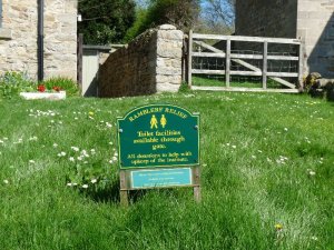
– because Thornton Steward, a quarter of the way through the walk, is a picture postcard of a village. There’s a green where you can rest for a while whilst looking beyond the cottages to Wensleydale beyond. Even better, there is a village hall. You won’t find anyone there, but the door is open. The villagers encourage you to come in, make yourself a drink, help yourself to a biscuit, and have a ‘comfort break’. Whilst relaxing, you could browse the books on display in two large bookcases. Swap one of your own if you have one, or if not, make a donation and take a book away.
Thornton Steward Village Hall, all set to welcome weary walkers.
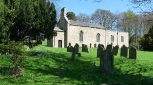
– because just outside Thornton Steward is the charming, tiny, isolated church of Saint Oswald. Mainly Early English, it still has fragments – parts of the nave wall and the porch door – dating from before 1066.
The church of St. Oswald.
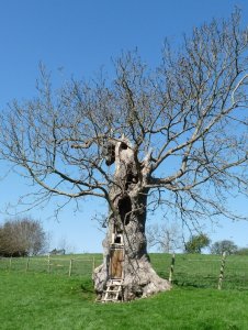
– because at the edge of a field quite near the church, some lucky child’s dad, or granddad has made a very special tiny secret den from an ancient hollow tree. Just look at this:
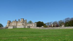
– because I passed Danby Hall, as well, begun in the 15th century and finally finished in the 19th century. Danby Hall was once the home of the Scrope family, a Catholic family of some influence who hid priests, attended clandestine masses and somehow survived the turbulent times of Tudor-Elizabethan England.
– because most of the second half of the walk is along the River Ure. On one side, it’s all woods, wild garlic and wood anemones. On the other, open views across the river itself, and Wensleydale beyond.
– because the route was so well way-marked that I barely needed a map to find my way round.
A style, a signpost, an easy route to find.
– and because of honesty boxes. That’s how you know you’re not in the city. Park at Jervaulx Abbey and there’s an honesty box so you can pay the parking charge. Visit the Abbey itself, and there’s another one. And at Thornton Steward they encourage you to make a donation for your refreshments: but no-one checks up: it’s up to you to do the right thing.
Thornton Steward advertises its ‘comfort break’ facilities.
On the walk, I thought of poor old Malcolm, stuck at home whilst I enjoyed one of the very first summer days, bright, fresh, and really rather hot. I thought of one of my fellow bloggers, Sharon, whom – very exciting, this – we’re going to meet in a fortnight or so when she comes to visit Yorkshire: she might like this walk. And I thought of another fellow blogger, Kerry, an American , who’d probably love to use the wool all those lambs and sheep are busily growing in one of her weaving projects, even though wool isn’t usually her chosen medium.
The path ahead, seen from the churchyard at St. Oswald’s.
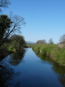
A sunny morning on the River Ure, just before we reached the Canal.
We went for a walk along the Ripon Canal the other day, starting from the point where it meets the River Ure. Back in its heyday during the Industrial Revolution, busy as it was then, the rural towpath we walked along might not have looked so very different. Back in its heyday, keels would have hauled coal northwards from the Yorkshire coalfields, and lead and agricultural products southwards. The canals were the freight-haulage routes of their age, and even though they were busy thoroughfares, the whole business of passing vessels through the three locks in one direction at a time limited the flow traffic to levels well below what those of us who’ve ever been stuck in a bad-tempered rush hour traffic jam on the M1 have experienced.
Ripon Canal is not one of the country’s great canals. There are water super-highways such as the Grand Union Canal linking London with Birmingham. That’s 137 miles long. There’s the Leeds-Liverpool Canal. That’s 127 miles long. The Ripon Canal runs for just two miles, from Ripon to Oxclose Lock, where it links with the River Ure. Like many of the country’s canals, it was built in the latter part of the 18th century, between 1767 and 1783, opening up water traffic between Ripon and York, and it eventually put the products of the Durham coalfields within Ripon’s reach.
The railways proved to be the death of canals all over England. Ripon’s withstood the opening of the Darlington to York railway in 1841, but the Leeds and Thirsk Railway finished it off. The railway company actually bought the waterway, to ensure local support , but they then neglected it, failing to dredge it, so that it became less and less useable. The canal was abandoned as a waterway in 1906.
But its fortunes have changed again. No longer a tool of the industrial revolution, the canal has become a playground for people who like ‘messing about in boats‘*. The Ripon Canal Trust spearheaded its restoration from the 1960s, and now the whole thing is managed by the Canal and River Trust. So whether you like boats, barges, or a stroll along a quiet backwater near town, Ripon Canal’s worth a visit.
Walking the towpath
Barges on the canal.
One of the canal bridges.
The towpath again.
*That’s what Ratty used to like to do in Kenneth Grahame’s ‘The Wind in the Willows’
The days are short The sun a spark Hung thin between The dark and dark. John Updike, “January,”A Child’s Calendar
A bright winter’s afternoon. Just time, before the evening cold sets in, to get out for a couple of hours of brisk walking: 5 miles or so along familiar paths. So familiar that this time, I focus on the sky: changeable, unpredictable.
Sometimes it’s moody, sometimes cheerful, sometimes simply rather grey and colourless, at other times dramatic, particularly towards sunset. Come and walk with me to watch the clouds.
I haven’t been on a ‘proper’ walk yet this year. First it was the ‘flu, and its aftermath. Then it was rain or snow on the days when I might have been free to get out for a blow in the breezy cold. And finally it’s the mud. Mud’s the one that gets me every time, despite having been given a wonderfully efficient pair of walking gaiters among my Christmas presents. I find it frustrating, pulling my boots from an oozing, slippery, sticky slick of mud only as a preparation for sliding into the next soupy puddle . It makes for slow walking on days when briskly striding out is what’s needed to combat the cold.
So today, keen to get out for at least an hour or so, and equally keen to avoid That Mud, I ended up on a star-shaped walk. I turned back down every path I started, and ended up doing a zig-zag circuit beyond the edges of the village.
Young kestrel feeding
I started off by looking for the young kestrel I’ve come across on a couple of days this week. I had first spotted him in a field near our house, dismembering and eating some small creature just 6 feet away from where I stood staring at him. He flapped off crossly to a nearby wall when he considered I’d got too close, and it was on this wall I saw him the next day too. Today he wasn’t there. I think there were too many dogs out walking their owners.
Beatswell Woods with extra water.
Then I went down into Beatswell Woods. I hoped for buds on the trees, or a few early flowers, but it was wet and wintry still. Then I walked to the fields, thinking I’d choose one of the paths there to take me in a big sweep round the edge of the village. No go. All the paths were muddy, and the horse I stopped to chat to had pretty filthy socks too. Though there was this rowan, with golden honey coloured berries instead of the more usual red.
Rowan berries against a chilly blue sky.
At the village ponds, the drakes and ducks ran fussily up to greet me, hoping for crusts. When they saw I had nothing, the drakes returned, like a bunch of fourth formers, to teasing and irritating the only couple of females in the group.
Drakes and ducks hoping for crusts.
But it was near the ponds that I had my second sighting of daffodils this year, so very early. Surely they should wait until the crocuses have put themselves about? But the crocuses are only just poking the tips of their leaves above the soil, and don’t plan on coming out yet.
Daffodils by the pond.
Returning to the woods, I saw the snowdrops. Isolated patches a couple of weeks ago, now they’re in magnificent great white drifts climbing the hillsides, nestling under trees, even risking everything by straggling across the (muddy) paths.
Drifts of snowdrops in the woods.
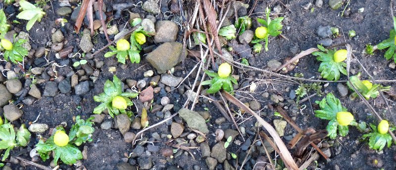
A bit of a curate’s egg of a walk then. A few frustrations, quite a few pleasures, but a healthy glow on my cheeks, and, just before I came into the house, another treat. All these aconites, pushing up their bright yellow faces through the soil, bringing with them hopes of Spring.
Today, I rejoined the human race. For the first time since before Christmas, I got up, got dressed, looked out of the window – and wanted to be out there, in the bright and frosty sunlight. Malcolm’s recovery is a good day or two behind mine, but I hope that he too is on the way up.
An early morning frozen pond
The first snowdrops
Frosty thistles
The promise of daffodils
Eleven o’clock shadow
Blue sky January
The sky reflected in the River Ure
Frosted leaves
Those Jacob sheep supervise me home every single walk.
I wasn’t up to a hike. I wasn’t even up to a stroll to the village shop, only a mile and a half away in West Tanfield. But I was up to a riverside amble, particularly when it meant coming upon little clumps of snowdrops on the woodland floor, already unsheathing their white faces to greet the winter sun.
Snowdrops push above the leaf mould
If the snowdrops are out and about, truly, all’s right with the world.
Ever since our friend Micheline had a nasty fall on a walk, three and a half years ago, and had to be air-lifted to hospital, I’ve been slightly wary of walking alone in the countryside.
But sometimes, only solitary will do. Never more than 4 miles from a village, always with a farm somewhere not too far away, I set off for a solo walk this morning, even before all the Grammar School pupils had got on their bus to whisk them off to school in Ripon.
From your point of view, as you look at these photos, you may feel it was all just a repeat of my Sunday morning stroll. But it wasn’t at all, not for me. My path drew me in a big eight mile circle to the west of our village. It took me past a working quarry: always good to watch men at work. It took me past ancient trees: our home patch is particularly good at oak trees which are very old indeed. As I was passing through a wood, an anxious Wensleydale sheep cantered up to greet me. I saw why she was worried. There wasn’t another sheep like her in sight anywhere – she was lost. But I never found anyone I could report her to. I hope she’s alright. There were fungi. There were delicate and skeletal winter seed heads. I saw a pint of milk delivered to someone’s gate, and took a picture of it. Home milk delivery’s getting scarcer here now than it was in my childhood, but I’ve never seen milkmen in other countries I’ve visited. I saw Autumn leaves still clinging to the trees, and plenty more in vibrantly coloured heaps at the base of trees.
Best of all – and I have no photo to prove it – shortly before the end of my walk, as I was climbing steeply through woods with the River Ure below me, three white-rumped deer leapt out of a clearing, and with three rapid yet elegant and beautifully choreographed bounds, disappeared from view, only to re-appear and disappear for good, moments later.
All in all, a pretty good use of a Friday morning, I thought.
Winter birds
Leaving home under the watchful eye of the Jacob sheep
An early morning sky
Big machinery at the quarry.
An ancient oak
This woodland will be deep in bluebells next April
What a difference a week makes. This time last week, Amelia and I were ‘recce-ing’ the walk I was due to lead this Tuesday, stumbling around near Swinton trying to make sense of a map and a warren of pathways. Both reasonably competent map-readers, we found ourselves confronted by too many cross-paths, and too many waymarks that didn’t QUITE make things clear enough. We got there in the end, of course, having met in the course of our journey several equally puzzled hikers turning their maps every which-way as they tried to choose the correct route.
This week, I competently led seven Ripon Ramblers on the walk and wondered why we’d found it all quite so difficult. But it got me thinking about all those paths. Paths are created by those who use them. Roads were too, once upon a time, as all those single track and often ill-repaired ‘C’ roads meandering from village to village testify.
But these days, roads are planned. It’s town planners, the Highways Agency, and whole bevies of committees who decide where roads will go, and how they will get there. If they deem it necessary, they will flatten hillsides or even communities that stand in the way.
Usually. There’s that famous farm in Calderdale which parts the two carriageways of the M62, the motorway which links Yorkshire with Lancashire. Legend has it that at the planning stage, the farmer refused the blandishments of every official from the Department of Transport, every civil servant who tried to persuade him that The Road Must Go Through, till finally Officialdom gave in and built the road around his farm. Sadly, it’s not true, and you can read about it here Still, whatever the truth of the story, it nicely illustrates the fact that these days, road are normally built where planners decide.
Stott Hall Farm in the middle of the M62. Photo courtesy of Wikimedia Commons
With paths, it’s a different story. Those routes that we use every time we go out walking in the country were chosen by those who did the walking, often many centuries ago. Well-trodden paths that have linked communities over the years are public rights of way that have to be kept useable and maintained by local councils in just the same way as roads must be. Local authorities have a duty to ensure that they are useable by installing gates and stiles to enable users to, for example, cross from field to field. Landowners who wish to vary the route of a path must have good reason, and must provide for and maintain a viable alternative.
On Tuesday, we went along a whole variety of paths, as we always do when out walking. Some were fine tracks covered in chippings and linking farms. One path was straight and wide with fine stone foundations: once it was a railway line built to haul goods to a reservoir under construction in the early 20th century. But much of the time, we could pick out our routes across farmland only by observing a sinuous line of flattened grass where others had walked before us. I enjoy knowing that most of these paths, whatever kind they are, have often been used for decades and even centuries before.
Needs can change though. That day when we first tried the walk Amelia and I had a dreadful time looking for a certain path. We even ended up at a farm asking for directions. ‘You’ll never find it’ we were told. ‘Nobody’s used it for ages, and it’s hopelessly overgrown. You’d much best use the road’. Well, it didn’t really suit us, but we could see why it had happened. The road was more direct than the old path so people ‘voted with their feet’ and stopped using it.
We’re pretty lucky to have a great network of paths. And besides that, in large areas of the country, we have ‘the right to roam’, meaning we’re free to explore the open countryside away from paths, following the Countryside and Rights of Way Act, introduced in 2000 after a 60 year campaign. I’m enjoying those paths, whether mooching, walking purposefully, exploring, or simply ‘following my nose.’
A grassy path.
Once this was a railway track.
A path that’s a road as well.
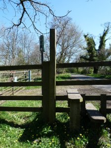
A stile on a path.
A path through a field.
A path that’s a bridge.
A finger post points out the path.
The Ramblers association does much to promote the interests of walkers and protect the walking environment.
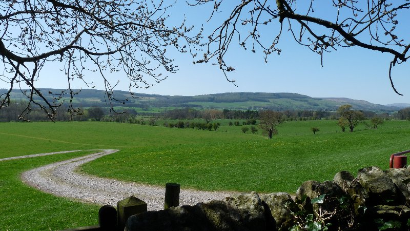
We travelled the road to our last walk in thick white mist, fearing a dank and gloomy day. But the higher we climbed, the more the mist fell away, and the brighter the sun shone.
Looking down over Wensleydale from Castle Bolton.
This was the scene as we arrived at Castle Bolton, the village where you’ll find Bolton Castle:
And as we began walking, Daphne shared some of the castle’s history with us. It has belonged to the Scrope family since the time it was built in the 14th century, and has always been admired for its high walls. It’s a proper castle, looking exactly like the ones you will have drawn when you were eight years old.
Bolton Castle
But that’s not why it secured its place in the history books.
Tudor history is largely about the constant religious and temporal battles between the Catholic and the Protestant church, which Henry VIII had made the Established Church, with the king as its head: the Fidei Defensor – Defender of the Faith (unbelievably, Henry hung onto this title, awarded him in his pre-Protestant days by Pope Leo X, in recognition of his book Assertio Septem Sactramentorum which defends the supremacy of the pope). His son Edward briefly succeeded him, and then his daughter Elizabeth, and both were Protestants.
But Elizabeth’s rule was threatened by the Catholic Mary Queen of Scots, and she was held captive first at Carlisle Castle, then at Bolton. Here she was attended by 51 knights, servants and ladies-in-waiting, not all of whom could be accommodated in the castle itself. She also had cooks, grooms, a hairdresser, an embroiderer, an apothecary, a physician and a surgeon, while furnishings fit for a queen were borrowed from nearby Barnard Castle. She went hunting, learnt English – for she spoke only French, Scots and Latin – and spent time with local Catholics. She made an unsuccessful bid to escape from captivity. It’s said she climbed from an upstairs window in the castle, and fled on horseback past the nearby market town of Leyburn. It’s here she dropped her shawl and so was discovered and recaptured. And that is why, so they say, the long escarpment above the town, nowadays a playground for walkers and sightseers, is still called ‘The Shawl’.
As we enjoyed our history lesson, we passed a field of Wensleydale sheep. We very much admired their sultry fringes.
Wensleydale sheep
And onwards. Autumn colours.
A completely pointless stile in the middle of a meadow.
Then Aysgarth Falls. What a wonderful lunch spot. The crashing waters made conversation quite impossible, but we sat enjoying the surging waters, the coppery leaves above our heads, and the all-encompassing percussion of the tumbling River Ure.
And then it was time to turn round and head back by a different route. Another great day’s walking, with an added history lesson.


You must be logged in to post a comment.