Take a walk through much of rural Nidderdale in North Yorkshire, and almost the only sign of human endeavour that you’ll see is connected with agriculture. Go out into this lightly-populated area, with its apparently nearly barren hillsides, and you’re only likely to meet sheep, with the occasional field of cattle.
Yesterday, we went to Greenhow. It’s a charming, pretty village more noted these days for being the highest village in Yorkshire: a whole 400 metres or so above sea level. It used to be an industrial power-house. It was here and in the surrounding area that villagers used to mine for lead. And the signs of this ancient industry are still here. We set off on a walk across moorland and valley to investigate.
It’s thought that the Romans were the first to mine lead in the area, and by 1225, the abbots of Fountains and Byland Abbeys were apparently squabbling(!) over rights to mine at nearby ‘Caldestones’. This valuable commodity was transported over, for the time, immense distances. In 1365 for instance, a consignment was sent to the south of England, to Windsor: ‘Two wagons each with ten oxen carrying 24 fothers* of the said lead from Caldstanes in Nidderdale in the county of York by high and rocky mountains and by muddy roads to Boroughbridge’. At which point, the journey perhaps continued on water. Indeed, lead was exported as far afield as Antwerp, Bordeaux and Danzig.
An all-but hidden tunnel.
Peering into it. We were too tall to stand upright.
What’s left of an old lead works.
The beginnings of a long journey for that now-smelted lead.
Well, we were on those ‘high and muddy mountains‘, but they didn’t cause us too much trouble. Comfortable walking boots and a bright sunny day probably helped us on our way. What we did see were warrens of carefully constructed and stone-lined tunnels leading to the ancient and now fully-exploited lead seams. We saw, in the small streams now coursing along some of them, how water became a real problem to the miners of those seams. Horse tramways hauled lead , which was smelted on site, off to what passed for major roads at the time. It was obvious to us how very difficult transport must be in this up-hill-and-down-dale area, which even than was not highly populated, with poor transport infra-structure, and unsophisticated wooden carts to carry the goods. Ancient spoil-heaps from now-exhausted seams litter the area.
An old lead-works, spoil heaps, a river and a perfect picnic spot.
And at the end of our journey, we strode up to Coldstones Cut. This is a fine art work, a vantage point from which to see a vast panorama of the Nidderdale Area of Outstanding Natural Beauty and beyond, as well as the last working quarry in the area. These days, it’s all about aggregates and asphalt, but the quarry has a long history of providing lead, then limestone as well as other materials. Andrew Sabin‘s viewing area is part streetscape, part brutal stone-block construction. It’s a magnificent intermediary between an immense and busy industrial landscape, and the gentler and even vaster rural one in which it’s situated.
Even at Coldstones you can’t escape the legacy of the Tour de France.
The quarry: hard to convey a sense of its scale.
That qualifies as a mountain round here.
A view from Coldstones.
That’s Nidderdale.
The monumental viewing area.
…and from another angle….
Nidderdale again.
A final view.
*An old English measurement equalling about 19.5 hundredweight.
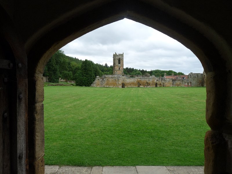
As you travel round North Yorkshire, you quickly become aware of its Christian heritage, and realise how many abbeys and monasteries there were, from a variety of religious foundations, for Henry VIII to get his teeth into once he’d laid his plans for the Dissolution of the Monasteries in the 1530s.
Fountains Abbey, as I mentioned in a recent post, is just down the road, and Jervaulx and Rievaulx aren’t far away: there are at least a dozen more. And each of them is ruined, left waste after Henry VIII pensioned off or martyred the abbots, priors, monks and lay brothers, and all the equivalent females too.
Today we visited Mount Grace Priory near Osmotherly. We’re accustomed to making a tour, when we visit these religious sites, of chapels, refectories, kitchens, cloisters – places where monks or nuns and lay brothers or sisters gathered together in spiritual or physical work for the benefit of their own and perhaps the wider community.
Not so at Mount Grace. This community was a Carthusian foundation. The Carthusians developed their order as a reaction to the lax conditions tolerated by many other religious orders at the time – the late 11th century. Initially centred on Chartreuse near Grenoble, the order founded religious houses throughout Europe, reaching Mount Grace in the later 14th century.
The simple, unadorned architecture of the priory.
Seven years is the time it took to become a full Carthusian monk. Seven years in which to decide whether the full religious life of solitary prayer, contemplation and work was for you. Seven years in which you would only ever see your fellow monks on a Sunday, at Chapter meeting. For the rest of the time you lived completely alone in your own little house which gave onto the large Great Cloister. Here you had a room in which to sleep and pray at the proper appointed times, a small living area with a large hearth, and upstairs, a room where you would work. Perhaps you would weave, or write out or illustrate manuscripts. Sometimes you would grow vegetables or fruit and herbs in your little patch of garden. You might walk or meditate in your very own mini-cloister. Even mealtimes were solitary. Your (vegetarian) food for your twice-daily meals would be pushed through a space in the wall by a lay brother whom you never saw. Bedtime was 6.00 p.m. and there were two extended times of prayer through the night. What you also had, though, extraordinary for medieval times, was a privy regularly flushed from springs in the area, and cold piped running water.
The monk’s bedchamber and personal chapel.
His sitting and dining area. There’s a large hearth here too.
His upstairs workroom, with weaving loom and table.
His privy.
His vegetable garden.
The writing equipment a monk was issued with on arrival at the priory.
The monastery site includes a prison to confine brothers who became disobedient. At a time when mental illness was little understood, surely some must have reacted badly to this life of extreme solitude, and become ‘problems’? Any yet there were always far more men wanting one of the 25 places at this austerely- run yet comfortable priory than could be accommodated.
The lay brothers who did much of the ‘housekeeping’ led similarly solitary lives, as far as their working day permitted. They farmed, made domestic pottery ware, looked after working animals, and the fish ponds: fish were apparently sometimes served as part of a vegetarian diet.
One of the several fishponds.
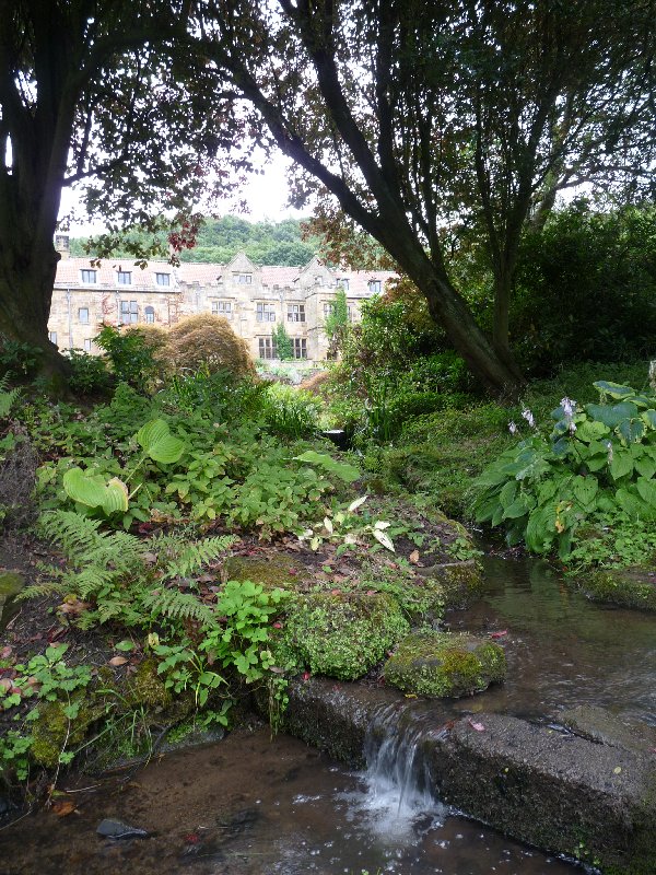
Naturally women were never permitted on site. Both male and female pilgrims would stay in what is now the Manor House from time to time, as monasteries have always had an obligation to offer shelter to travellers.
Since the Dissolution, the priory and its surroundings have been abandoned and fallen into ruin. The surrounding farmland was sold off, and the Manor House was converted and adapted for family life at various times in both the 17th and 19th centuries. The refitting of the house in the popular Arts and Crafts style at the turn of the 20th century deserves a post of its own.
Mount Grace is a lovely site. Malcolm and I were happy to visit it together, to have the chance to talk to informative and enthusiastic staff, and to wander around at our leisure. Living there for an entire adult life, under strict Carthusian rule? Not a chance.
This is the Manor House as it appears today, viewed from the garden and fishponds.
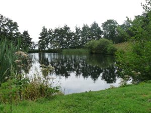
Not far from here, only about two miles as the crow flies, is a nature reserve, Nosterfield Local Nature Reserve. And ‘as the crow flies’ is an appropriate way to measure the journey there, because above all else, it’s a bird reserve. Even more than that, it’s a wetland reserve.
Evening at Nosterfield.
Until the 1990s, this was a landscape quarried for its sand and gravel, exposing the underlying limestone and fluctuating water courses. Even as the land was worked birds flocked here in search of insects. Once the quarries closed, the land proved unsuitable for agriculture: the intermittent flooding saw to that.
Wildlife took the site over. Wading birds adore the muddy margins and insect-rich grasses. Natives such as lapwing and curlew breed here, whilst many other species, such as sandpipers and godwit drop in as they migrate. Dozens of other species of bird make this their home, holiday destination, or stop-over site. At the moment, harvest time, Canada geese are exploiting the riches of the harvest. If they’re not noisily camping out in the wheat field just behind our house, you can be sure they’ll be at Nosterfield.
Great crested grebe.
Oyster catcher.
Heron
Since 1996, the area has been a nature reserve. A group of local naturalists succeeded in buying the site, having formed the Lower Ure Conservation Trust. They manage the site to exploit its already abundant resources. The fluctuating water levels – up to three metres a year variation is not unknown – means that there is everything from muddy shallows to small shallow pools to deeper sheets of water. There’s something for everyone, if you’re a bird who likes water. Or even if you’re a bird such as a wagtail, linnet or twite, who doesn’t.
The site supports a huge variety of wild flowers and grasses. That means there are insects, butterflies such as common blue, brimstone, wall brown and white-letter hairstreaks and moths too. There are rabbits and hares: while voles and shrews are preyed on by kestrels and barn owls. Summer-grazing cattle and sheep assist in managing the landscape: one way or another, this is a success story.
A busy evening at Nosterfield
We simply aren’t birders. Not yet. But this reserve is doing much to help change all that. There is a series of well-managed hides, and best of all, a comfortable unstaffed information centre, with piles of illustrated leaflets and books to help us identify what we’ve seen. It’s a serene and beautiful place to spend a quiet couple of hours watching the soap opera of bird life unfold, as they feed, raise young, quarrel, swim and wheel about above. We love visiting at different times of day, and look forward to coming throughout the seasons to see how the local bird population changes. By this time next year, we may be able to identify much of what we see. Maybe.
If you drive through Kirkby Malzeard and take signs to Dallowgill, you’ll find yourself leaving rolling green Nidderdale countryside for a more open and bleaker moorland landscape. There’s a place called Tom Corner where you can park, and that’s where you can start the Crackpot Trail.
The view at the start.
The Crackpot Trail? Well, back in 1996, Rural Arts worked with a group of villagers in Kirkby Malzeard to devise and make a series of 22 mosaic plaques to distribute over the route of this circular walk. They chose subjects to celebrate what the walker might see en route: animals, birds and flowers such as sheep, curlews, fungi: local features such as the Potato House, where potatoes used to be stored: and there right at the beginning of the walk, a Roman centurion, to commemorate the fact that many years ago, Roman bones were excavated at this rather wild and windy spot.
Our moorland path.
It’s a wonderful walk to see the varied landscape of this part of the Dales. From the moorland, where at this time of year heather is just beginning to burst into bloom….
Early heather.
…. the path takes you back to gentler, farmed countryside, with views of stone-built farms and hamlets across the hillsides.
The landscape opens out.
You’ll cross peaty streams…….
A stream to cross.
….. and walk though ancient oak woods which at the right time of year are carpeted in bluebells. There’s a bit of everything, even a lunch spot about half way round, at a former pub, the Drover’s Arms, which sadly burnt down in 2013. But the fire didn’t get the picnic tables: they’re still there for you to sit and eat your sandwiches.
Our drama for the day. This poor sheep was well and truly trapped. Somehow, we extricated her…..….while her companions looked on.And this is their daily view.
A perfect, easy and enjoyable day, because this varied, pretty and scenic walk is a mere six and a half miles. You’ll be home in time for tea.
That’s Ripon over there. We’ve just finished our walk, and it’s about to rain.
North Lees, the hamlet after North Stainley, welcomes the Tour.
The final post about le Tour de France. I promise. Because it’s actually over, as far as Yorkshire’s concerned. And as far as poor old Mark Cavendish is concerned too.
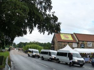
But Saturday was all about Stage One of the Tour. Up early, I dashed over to the next village, West Tanfield, to buy a paper before the road closed for the day. Six mini buses were disgorging security guards who immediately took up positions round the streets. What could be going on? Later, I found out. ‘Wills and Kate’ ( the Duke and Duchess of Cambridge to you, please), due to open the Tour at Harewood House between Leeds and Harrogate, were to be helicoptered into West Tanfield at 1.00 o’clock. Later still, we discovered that my friend Penny was among those who had been presented to the Royal couple – and to Prince Harry too – since her husband’s Chair of the Parish Council there.
West Tanfield would have been a good place to be for other reasons. The riders swoop down a hill into the village and make a sharp turn over a narrow stone bridge before the long straight run into North Stainley. So there were vans from radio stations, cranes ready to hoist TV cameras aloft, and would-be spectators galore, already taking their places at prime spots and keeping the local pub and shop busy.
The busy streets of West Tanfield, 8.00 a.m. , Tour Stage One.
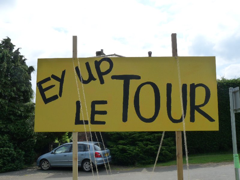
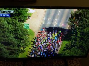
But we’d decided to stay put. Daughter and family had come over from Bolton and we decided that we should profit from the fact that the Tour actually passed the end of the drive. We sauntered down to the village to the stalls on the cricket pitch, and watched a little of the early action on the big screen in the village hall. Back home, we spent a happy quarter of an hour chalking ‘Ey up, Laroque’ on the road to greet all our friends in France when the TV cameras passed over. It worked, as my camera shot of the TV screen proves. But it only lasted a second and nobody but us saw it. Ah well.
If you’d watched the TV attentively, you’d have seen our greeting.
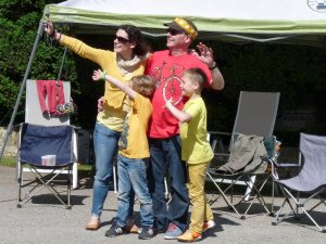
What we saw though were billboard adverts that appeared for the duration all along the roadside for companies that don’t exist in England – PMU, Carrefour – and which had already disappeared an hour after the racers had passed through.
Ellie, Phil, Ben and Alex welcome the publicity caravan.
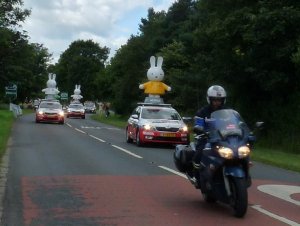
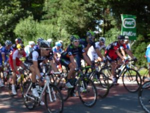
Then, finally …. tour officials in their Skodas…. British police on motorbikes….. French gendarmes on motorbikes….. support vehicles… and the publicity caravan. It wasn’t as extensive as it had been in France, but there WERE vehicles advertising French companies we don’t have in the UK, as well as British ones too. The total haul of freebies my grandchildren had thrown towards them consisted of two Skoda sunhats and a key ring. And then …….. the riders. Amazingly, after five hours up hill and down dale they were still riding in a solid phalanx, whirring towards us as a purposeful army. And then…. they were gone. Team vehicles loaded up with spare bikes aloft, more police and ambulance support followed…. and it was over. For us. Time to switch on the television and follow the action into Harrogate.
Rabbits on Tour.My shockingly bad – and only – photo of the riders passing our gate.
Disappointingly, my crop of Tour photos is exceptionally poor. So I’ll focus on a final look at North Stainley, which took the Tour to its heart, and delivered a very special homage to France and the Tour de France.
An early rider on the Tour
Here’s a close-up.
Another contender.
And another
A decorated wheel.
A garden decorated for the occasion
The Brownies decorate the cricket pavilion.
Bunting and yellow bikes.
A French lawn.
Another yellow bike.
Frank Bailey’s extremely clever revolving sculpture.
The village symbol, constructed from bicycle parts.
All the school children re-interpreted French Impressionist paintings.
The village had to have a few knitted Tour jerseys too.
A re-interpretation of Monet’s ‘Waterlilies’ on the village pond.
The church gets in on the act. ‘Le Moulin Jaune’.
Younger children at the school decorated pennants.
One of the banners at the school
Another wheely good decorated wheel.
North Stainley’s own ‘Man of the Mountains’ house.
Bill? Ben? Or a TdF cyclist?
Ooops. Someone just crashed.
The garage, now closed, has a special display of 2CVs
Even isolated houses in the country get in on the act.
Cheerful bunting in Addingham
Little knitted jersey bunting in Ripley
Red white and blue bunting; yellow, green, white and spotted bunting; multi-coloured bunting: that’s what you’ll see as you pass through the Tour de France communities of West Yorkshire, and Craven and Richmondshire in North Yorkshire. Here in Harrogate District, and in Hambleton too, it’s those jolly little knitted jumpers in all the Tour-jersey colours that are festooned round town.
Follow the signs to follow the route.
We know, because yesterday we got up betimes, had a healthy breakfast, packed maps and drinking water and set forth to Ride the Route for Day One of the Tour de France. On our bikes? Not likely, though many people are doing exactly that. We took the car, because the whole circuit is 195 km. long. The Tour riders will get that done in not much more than 5 hours. We were out of the house for 9 hours.
Leeds celebrates the Tour de France with a series of cheerful banners.
We didn’t quite do the lot. From Leeds, the riders will take it steadily till they get to Harewood House, between Leeds and Harrogate, and that’s where the race will begin in earnest. So that’s where we began too, though unlike the competitors, we couldn’t ride through Harewood’s grounds. So join us as we begin our own Tour, not far from Pool-in-Wharfedale.
A cheerful bike at Pool-in-Wharfedale
A butcher’s window in Otley.
On the route in Wharfedale.
Skipton Castle sports a yellow jersey.
The route near Skipton, warning the road will be closed on the day.
The road near Rylstone.
An easy stretch of the route.
Climbing towards Kettlewell ….
….. and descending again.
The scenery here is the gently rolling countryside of lush fields and woodlands that characterise Lower Wharfedale: it’ll break the riders in gently. Through Otley and Ilkley, our winding road took us through quiet pretty villages on into Skipton. Now we approach the Yorkshire of soaring fells and dramatic limestone scenery whose fields are bounded by dry stone walls. The area round Kettlewell used to be important for lead mining. These days sheep and tourists – walkers and cyclists – provide the village’s income. Unlike the cyclists, we paused for a leisurely lunch at the King’s Head. Fabulous food, with friendly service. Very highly recommended, but perhaps not if you have to ride ever upwards over the fells after you’ve eaten.
Kettlewell. Look for that Tour jersey up there on the hillside.
As you travel northwards, then westwards from Kettlewell to Hawes, via Buckden, Thoralby, Aysgarth and Bainbridge, you’ll be climbing through increasingly dour and empty hillsides. I love their severe beauty, and relish too the occasional descent into the valleys where once again the road passes through glades of trees leading to picture-postcard villages.
The road near Buckden.
Only sheep for several miles.
The climb continues.
A novel way of advertising cheese: on the side of a hay bale.
Bainbridge welcomes the Tour.
A house outside Bainbridge welcomes the Tour.
Then Hawes. Hawes has taken its duties as Gatekeeper to Buttertubs pass, where the King of the Mountains will gain his crown, very seriously. The King of the Mountains gains a red-spotted jersey for his efforts, and Hawes has become a red-spotted town for the duration. Bunting, shop fronts and decorations, even whole houses have been painted white with large red spots. The effect is very jolly and festive, and Hawes, it’s clear, plans to have a great Tour.
A friendly French welcome at Hawes.
The Mulberry Bush welcomes the Tour….
… selling a right Yorkshire T shirt….
… and King of the Mountain mugs.
A house in Hawes.
Bunting in Hawes market.
But then it’s Buttertubs. There are few more dramatic roads in England. It climbs sharply, but there are sudden descents, unlooked-for tight corners and mile after mile of uninterrupted moorland view. If I were a Tour Groupie, this is where I’d want to be to watch on 5th July. At its highest point, the road can be seen as it swings right, left, up and down for many a mile. This is where those riders will be put to the test. But it’s not over at the bottom. Because here, the road chases round unexpected corners, bounces over small ancient bridges, darts in and out of woodland, narrows rapidly as it skirts past hamlets…. they won’t be able to relax for a second.
The road towards Buttertubs.
Welcome to the King of the Mountains!
Another fine welcome on the road from Hawes to Buttertubs.
Buttertubs.
The road at the top.
A cyclist rides the route.
By the time the riders reach Reeth, they’d feel entitled to a bit of down-time. But no. There’s another long moorland slog before, at Leyburn, civilisation kicks in once more. The villages become more frequent, the countryside softer and sweeter. We trundled in our car back home to North Stainley, having done the home-to-Harrogate stretch first thing in the morning on the way to Harewood.
A challenging descent in the village of Reeth …..
…. not over yet. Another moorland climb before Leyburn.
And at Leyburn, even the Parish Church joins in the fun.
We were left with an impression of how the Tour has fired the imagination of many communities through which it will pass. Not all of course, but many have seized the opportunity to build on the opportunity the Tour provides. They’ve involved everyone from the youngest to the oldest in generating understanding of aspects of French life, or of sport and cycling, of promoting the Arts in the widest sense, and in bringing the whole community together quite simply to have fun together, both in the period leading up to the Tour and on the day itself. Our own village is a case in point: more of that later. The once-in-a-lifetime opportunity the Tour presents means that it’s more eagerly anticipated here even than in France, where for years it’s been an important part of the summer calendar. Those people who’ve shuddered with dislike and arranged to go away for the duration may come to think they’ve missed out on something quite special, and uniquely enjoyable.
A cheerful corner in the next village along, West Tanfield.
Malham: a place that sums up Yorkshire scenery and countryside, and a geology lesson in a landscape.
We – the Ripon Ramblers – had come to walk from Malham to the cove which shares its name, then on to the Tarn and then make a circuit of the way back to the village. It’s a longish car trip for us to get there, but we thought it was worth it to enjoy the wild and rocky scenery with views far across dry-stone wall enclosed fields to the Dales beyond.
Once cultivated fields are now given over to grass and sheep.
Malham Cove is a large curved limestone cliff at the head of a valley across which water used to tumble as a glacier melted above it. The stream that once cascaded over the cliff now disappears, like so many others in this land of porous limestone, into Water Sinks about a mile away.
The cove looks rather like an imposing and curtained castle wall or amphitheatre from which vegetation clings precariously. It’s immense, and however often you visit, it never loses its power to impress. We approached it walking along Malham Beck, a pretty stream which jostles and bubbles out of the cove, before we slogged up the 400 irregular rough-hewn stone steps alongside the cove which are part of the Pennine Way. It’s a tough climb, but rewarded every step of the way by seeing the Cove from ever-different viewpoints.
Malham Cove
Another view
The limestone pavement at the top
Wild thyme – and a few buttercups – thrive here.
Gillian – our leader for the day – surveys the view.
The path we tackled after our break
At the top, you’ll want to rest. We had our coffee-stop on the limestone pavement which carpets the area. That glacier all those years ago scraped and polished the limestone, and over the centuries, rain has niggled away at the soluble rock to divide the pavement into large irregular slabs called ‘clints’ and ‘grykes’. It sounds grey and sombre. But in fact there’s a rich diversity of tiny lime-loving plants such as wild thyme, limestone bedstraw, common rock-rose and bloody crane’s-bill – don’t you love those traditional names for these colourful flowers? . Above us, skylarks trilled, and the landscape before us rewarded our efforts.
A view from the path
After our pause, we continued along narrow rough and rocky pathways before hitting more open ground on our path to Malham Tarn. This is the highest lake in England, a shallow lake which, though surrounded by limestone, is itself on a bed of slate. It’s rather boggy round here. Pick your picnic spot, which you’ll be sharing with quite a lot of cows, with care or you’ll stand up after you’ve eaten, as I did, feeling distinctly damp.
Malham Tarn
Much more open landscape after that. We continued to climb… and descend, climb… and descend, always with those open views, and sheep or sturdy Belted Galloway cattle for company. Suddenly, the climbing was over. Before us was a landscape of ancient stone barns, of sheep enclosed in equally ancient narrow and irregular fields bounded by dry stone walls, and an unremittingly steep grassy path leading down to the valley and Malham, with its welcome tea shops. There’s so much more to explore here. But that will be for another day
The climb continues
Looking back towards Malham Tarn.
More limestone pavement.
Belted Galloway calves survey the scene.
It’s all downhill from here.
Still rocky here, but softer Daleside landscape over there.
Ancient barns, ancient walls.
A Swaledale sheep as gate-keeper.
A final glance at the hills and ancient field systems.
A stained glass window in Harrogate by Caryl Hallett celebrates the TdF
After seven years of living in France, we reckoned we were old hands at le Tour de France. It had gone past our house twice – once west-east, once east-west, and jolly exciting too, for roughly 30 seconds, which is all it takes for the competitors to go whizzing past… though there’s the no-small-matter of the caravan, and all its extraordinary vehicles full of excitable young women (only gorgeous young females and the occasional hunk need apply) flinging forth key rings, baseball caps, sweets and so on to the crowds scrabbling around for these souvenirs of the day.
And this year, for the third time in our lives, the Tour is going past our house again: because in 2014, for one year only, the Tour de France begins in Yorkshire, aka God’s Own Country. It’s quite a coup for Yorkshire tourism, as it’s an opportunity to showcase this wonderfully scenic area as a tourist destination to a world glued to its TV sets for the duration of the Tour.
Even letting agents are getting Tour de France fever.
Yorkshire has been going Tour mad for weeks – no, months. One of the earliest signs was last November, when the Harrogate Advertiser asked readers to knit little TdF jerseys to be strung as bunting in local streets. 3,000 jerseys should cover it, they reckoned. We now known that there are well over 10, 000 of them – yellow, green, white-with-red-spots, in Harrogate District alone, and who knows how many in the county as a whole, or down south when the riders complete the Cambridge to London stage? You can see them strung in shop windows, along house railings, swagged along churches, between public buildings or threaded through the branches of trees.
Outside a church in Killinghall
House railings in Killinghall.
… and a Ripon shop.
Then there are the yellow bikes. There are town trails to discover the dozens of yellow-painted bikes deposited round towns, in gardens, along country roads, in shop windows…. I’m sure many will be around months after the event, but many more will have been cleaned up and shipped off to various projects in Africa.
Yellow bikes: suspended from a pub…
…along railings….
… or simply along the roadside.
Our own community, North Stainley, has had Rural Arts working with the children at the Primary School to produce their own interpretations of impressionist paintings, and these are now on display round the village. The pond has got its own Monet style bridge with LED waterlilies for the duration. There are two new sculptures inspired by the Tour, and there’s a whole programme of social events. Every village and town along the route is involved in providing fun for residents and visitors alike on the weekend of the Tour. The description of choice seems to be ‘Le Grand Départy’. Please groan if you want to….
A splendid feat of engineering at North Stainley: Frank Bailey’s ‘Rotation Franco’ The wheels revolve in different directions.
North Stainley’s symbol, a stag, this time made of bicycle parts.
North Stainley’s take on Monet’s waterlilies.
Tour de France banner at the Primary School, North Stainley
The Folies-Bergere meets Betty’s. One of North Stainley’s impressionist pictures.
..and another ‘Impressionist’ picture
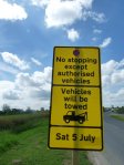
Roads along the route have been repaired and revamped, presumably to the detriment of the road maintenance programme of all highways not on the TdF course. Traffic islands in towns have been replaced by moveable versions, so they can be shifted from the road for The Big Day. Anyone with open land and the means to provide sanitary and other arrangements, from farmers to schools with big playgrounds, is offering camping or parking facilities for the duration. The French may well look askance at this degree of organisation, because over there it’s fine to turn up and park your camper van on any spare bit of mountainside that you can find. Here however thousands and thousands of would-be spectators all have to cram themselves along some 400 km. of route, as opposed to the 3,500 km available in France. Our village alone has been told to expect up to 7,000 spectators, the next village along, 10,000. The logistics are a nightmare, and forward planning essential.
These signs suddenly appeared at the end of last week.
We woke up to rain. So the question was – to walk today, or not to walk today? Malcolm said ‘no’. I, albeit reluctantly, said ‘yes’, and went off to join the Ripon Ramblers at our Ripon rendez-vous. It was still raining on and off, and as we struggled into cagoules and overtrousers in the car park at Grassington, the rain was definitely more on than off.
A moody sky as our walk begins.
Limestone scenery of the Dales.
Mountain pansies
Dry stone walls, a lonely tree.
All that remains of the rain.
Glaciation had its effect on the landscape, scouring the rock, and leaving deposits too.
Curlews on the skyline
You can see from the pictures that it was grey and forbidding. But these conditions lasted ten whole minutes. Then a breeze picked up and blew away the black clouds. Our Dalesway views became clearer and brighter. We spotted curlews on the skyline. We scrambled down a narrow ravine on our way to Conistone that reminded me of walking in the Gorges de la Frau back in the Ariège. And it was lunch-break time in picturesque Conistone itself.
The Gorges de la Frau look-alike.
Not easy.
But soon over
That’s all it was: a dried stream bed.
Conistone.
Another view of the village…..
…and the road leading out.
Our path continued
A barn unconverted for housing.
A meadow.
We spent the afternoon working our way back towards Grassington. There was a country lane, paths through fields bright with meadow flowers, and a long wooded section high above the River Wharfe. The prize here was the sight of a heron patiently fishing. He didn’t fly away as we came into view, but remained still, quiet, awaiting his fish dinner. Finally however, we passed too close, and he flew reluctantly away.
The patient heron
And then it was nearly time for us to end our walk, and claim our reward of a pleasant few minutes sitting out in the sunshine of a café courtyard, with toasted teacakes and a cuppa. We felt smugly satisfied that we’d braved the rain. What rain?
Grassington again. Journey’s end. And look. Blue sky!
A man walks in to the bakery with a tray of eggs, newly laid by his hens. He’s ‘paid’ in bread. A woman comes with a bag of rosemary from her garden: she too receives bread, still warm from the oven. Over there, at the back, another woman is steadily getting an enormous batch of scones ready for the oven, while in another corner, someone else is weighing out the ingredients to make biscuits.
Margaret Number 3 makes scones
We’re in the market town of Bedale (population four and a half thousand). More specifically, we’re at Bedale Community Bakery (or ‘Bread Actually’), tucked away behind the railway bridge next to the Big Cow Little Sheep educational farm. This is no ordinary baker’s shop. For a start, though there’s a busy team at work throughout the day, there are few paid staff. This is a not-for-profit community venture.
The generously-seeded multi-seed bread has just gone into the oven.
The sourdough moulds have finished their work for the day.
And here are rolls, ready to buy.
The bakers are paid – they’re the ‘bread and butter’ of the organisation after all. Then there’s hands-on Chairman Carol, and Sarah who seems to be involved in everything. But all the biscuits, cakes, scones – the non-bread items – are made by a willing team of volunteers managed by retired baker Alan. From today, Malcolm and I are part of that team.
Focaccia in waiting.
It was a wonderful experience. From the first moment, we were expected to roll our sleeves up and turn to. But the friendly welcome, the team spirit, the willingness to share and help each other, the generosity of spirit shown by everyone there made for an unforgettable first morning. Malcolm washed up and sliced cakes into even portions, and I helped Margaret ( ‘Not another Margaret, there’s three of you now’) make an entire batch of about 210 Anzac biscuits, bake them, cool them, and package them for sale in cellophane sacks of 6, closed with yellow ribbon. There was focaccia to part-prepare for the just-about-to-start Bedale BAMfest. There was more washing up, and sweeping and cleaning. And time for a coffee-stop of course.
Two Margarets make Anzac biscuits.
Anzac biscuits partly packaged…..
…. and ready for sale.
They’re seeking to build up the customer base. There’s a country house, a high-end hotel or so, and various other outlets who like the quality and range that the bakery offers. There are locals of course, who know a good thing when they find it, because there are always samples of the bread to taste, people around to discuss ingredients and recipes, and a constantly changing repertoire. Today there was multi-seeded bread; cheese, chilli and – oh, crumbs, I’ve forgotten what else – sourdough; rosemary and black pepper; cheese, chive and onion bread; harvester loaves….. and so on and so on. This is Slow Food at its best, made with locally sourced flour from Crakehall Watermill with not a single flour improver, and proved gently over several hours to develop the flavour. Recipes are carefully tested and recorded, and every opportunity is taken to use seasonal flavours and ingredients offered from the community: a glut of fruits or herbs, as well as those eggs and that rosemary.
Off-duty loaf tins.
I hope there’s plenty more to tell about this place. We think it’s worth the 16 mile round trip to volunteer here (and be ‘paid’ in bread), but others come from much further afield: Redcar, the home of one of the team, is nearly 40 miles away, and Saltburn, where another lives, 50 miles. We all appreciate good bread, and recognise a worthwhile project which offers the chance to learn new skills in a supportive and ‘can-do’ environment.


You must be logged in to post a comment.