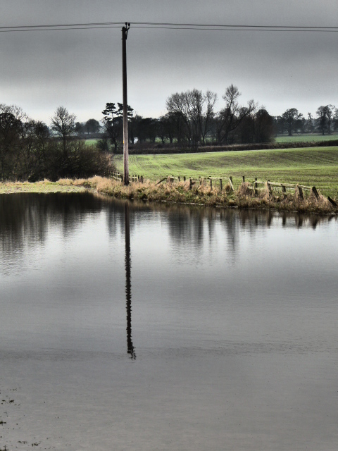
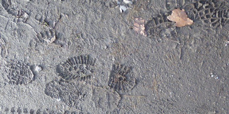
Look. Here was the scene in the field near our house, in January this year. Fields and roads flooded, impassable pathways, rocks and earth tumbling into the River Ure.
Near Old Sleningford, January 2016.
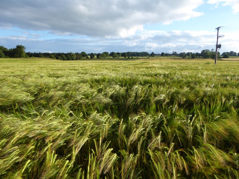
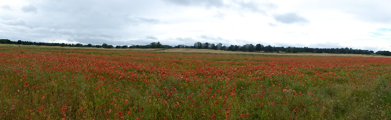
This was the same field yesterday. Barley, barley everywhere, all fattening up nicely for the harvest. Nearby, fields of poppies. Really hopeful, cheery sights on a sunny and blustery day.
The same field, July 2016
Will all our present political crises end so well? I wish I could feel more optimistic.
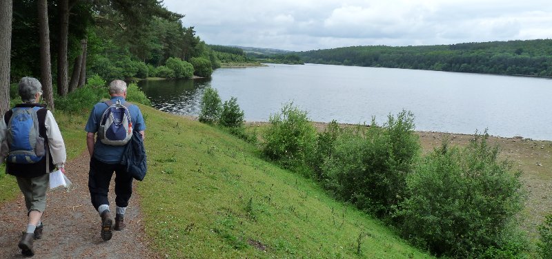
We went for a walk from Leighton Reservoir this week. It’s in many ways a bleak, bare, sometimes boggy landscape, and this suited our mood in a bleak, bare post-Brexit week. The view is softened at the edges by the rolling, green, stone wall-skirted Yorkshire Dales which lie beyond the heathery moors.
But look what we found as we consulted our Ordnance Survey map. These were the places we passed, or could see at a distance:
Sourmire Moor
Gollinglith
Baldcar Head
Jenny Twigg and her daughter Tib (Two natural stone stacks towering out of this boggy moorland landscape. We didn’t get as near to them as we’d have liked this time)
Grewelthorpe Moor
Benjy Guide
Sievey Hill
Horse Helks
Cat Hole
Jenny Twigg and her daughter Tib (Wikimedia Commons)
Really, where else could we be but Yorkshire?
Postscript: Just at the end we met this little chap, a just-fledged thrush. We hope he (she?)’s ok, because he just about managed to fly rather stumblingly off to a safer place than the track where we spotted him.
This was a fine day for a walk, and a fine day to have a few history lessons thrown in
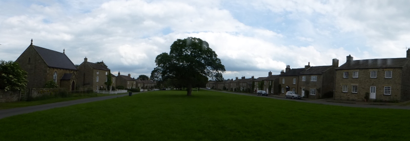
This is what we did. Here’s our starting point at East Witton, about 15 miles from home. It’s a lovely small village of about 250 people, where most of the houses were built in the early 19th century round the extensive village green.
East Witton
We passed through fields with views across the Dales. We walked along a green lane, through woods, and eventually reached a wooded gorge through which the River Cover runs, and where we crossed over the charming stone bridge known as the Hullo Bridge. It was quite a climb up the hill on the other side, and we were hoping for glimpses of Braithwaite Hall. Too many trees in full leaf. We hardly glimpsed it.
It’s built on the site of a grange belonging to Jervaulx Abbey. After the Dissolution of the Monasteries it continued as a sheep farm, as it had been under the monks. This is an area where the monks of both Jervaulx and Fountains Abbey extended their influence widely: enormous numbers of sheepall over the region were managed from local granges where the lay brothers who cared for them lived.
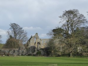
The ruins of Middleham Castle.
We were nearly in Middleham now. This is above all a horsey town. The monks of Jervaulx bred horses, and brought them to the Moor to exercise them. When the monks eventually went, the horses remained, as did the training tradition . Middleham these days is home to around 15 racehorse trainers and 500 horses, yet it’s a small town of hardly more than 820 people. It was too late for us to see the horses out on the Gallops this morning, so instead the first thing we saw was the castle, which dates back to 1190 and was the stronghold of the powerful Neville family from the 14th century. Richard Plantagenet, later Richard III was sent here as a young man to be trained in arms by Richard Neville, Earl of Warwick, his cousin.
The earliest known portrait of Richard III (Wikimedia Commons)
Warwick had the bad habit of changing sides throughout the Wars of the Roses (1455-1485) depending on whether the Yorkists or Lancastrians had the upper hand. Eventually he came to a bad end when he was killed by the Yorkist King Edward IV and his younger brother Richard. Edward gave Middleham Castle, and much else to Richard who lived there with his wife, virtually ruling the North of England, for 11 years. When Edward died, Richard seized the throne and reigned for only 2 years before dying in August 1485 in the final battle of the Wars of the Roses, the Battle of Bosworth in Leicestershire. And there his body remained for 517 years, before being exhumed from a car park in Leicester in 2012.
For us, Middleham was the site for a rather good picnic, followed by a visit to a teashop for an indifferent cup of tea, and even more indifferent cake. But the calories were useful. There were stiles to cross into fields deep in cut grass, waiting to dry off into hay: a fine walled track Straight Lane – to walk along before reaching the River Cover, languidly passing over bleached white stones on its way to meet the River Ure. We briefly touched the road once more as we passed Coverbridge Inn. This dates from 1684, and was owned by the same family – the Towlers – till 1930. Local legend has it that when the monks of Jervaulx were forced to disband in 1537 at the Dissolution of the Monasteries, they shared their secret recipe for Wensleydale cheese with the Towlers. We shall never know.
A final walk along woodland paths, open farmland, fields enclosed by characterful drystone walling and we were back in East Witton. A grand day.
It was my turn to lead a walk on Tuesday. I chose Coverdale. Here’s why.
The River Cover, which gives the dale its name, wanders through an isolated corner of Wensleydale. Here you’ll find hamlets with intriguing names like Swineside, Horsehouse and Gammersgill, a few abandoned leadworkings, a great many sheep, and not much else. The principal settlement, Carlton, has 230 inhabitants and the main – the only – road to it is mainly single track. This is where we began our walk.
Here were hillsides, close-cropped by sheep. Here were ancient terraced field patterns showing that the area, even if lightly-populated now, has long been settled by farming communities. Here were narrow steep-sided gills sheltered by glades of trees. It offered a walk full of variety.
Sheep with her lambs.
We yomped up and across meadows populated by those sheep and their curious, always hungry lambs, enjoying long-distance view across the fells. Curlews called above us.
Curlew – Wikimedia Commons
We climbed over wooden stiles, stone stiles, ladder stiles and through narrow-gap-in-the -stones-stiles. As we passed though woodland we sniffed the slightly acrid but appetising tang of early wild garlic.
Our coffee-stop view across the valley. Those stone barns are typical of Wensleydale and Coverdale.
Soon we could see our half-way point on the other side of the valley. Horsehouse these days is a tiny collection of isolated homes. But it gets its name from the days when it was a really important staging post for those making the long journey from the north (even as far away as Edinburgh) to the south (London?).
And once we’d crossed the River Cover, we were in woodland again. We found a grassy bank, complete with bluebells, tree trunks to sit on, fat white pebbles for the waters to tumble over: perfect comfort, perfect peace.
We had a young German guest, Felicia, with us for the day. You can see she’s 40 years younger than the rest of us. She’s climbing trees after the picnic.
After lunch, curlews gave place to oystercatchers, with their smart black and white plumage and vivid orange beaks.
Oystercatcher – Wikimedia Commons.
And then we came to the point in the walk where the instructions read ‘Turn left at the last stile’. How mystifying. How can you possibly know which the last stile is till you’ve passed way beyond it and not found another? Ever-resourceful we found our way anyway, strode through Gammersgill, across a few final fields, and got to journey’s end not long before the day’s sunny warmth gave way to wind and showers.
Easter holidays. Time to have those ten-years-old grandsons over. Time to keep them so busy they don’t have a chance to realise that ours is not a home stuffed with devices. Not a smart phone in sight.
Let’s get them back to the past straight away, even before we get them back to our house. Are they too old for an Easter Bunny hunt at Fountains Abbey? Apparently not. Not when there’s a chocolate bunny to eat at the end. Are they too cool for egg and spoon races and egg-rolling down the hill? Apparently not.
Egg-and-spoon race.
Egg rolling.
Would they like to visit ‘Forbidden Corner’? They agreed they would, even though we failed to provide a description of what to expect. We couldn’t. It’s been described as ‘The Strangest Place in the World’. Perhaps it is. It’s a folly. It’s a fantastical collection of follies. It’s woodlands, walled gardens, mazes, tunnels, grottoes, built in the manner of a topsy-turvy collection of fairy tale castles in enchanted grounds. Every stone putto is liable to pee on you as you walk past. Every passage is too narrow, too low, too dark, and may lead nowhere. You just want to try to get along it anyway, because at the end there may be another secret door, with halls of mirrors, or ever-changing fountains, or grotesque stone gremlins, or stepping-stones …. And beyond, in every direction, the glorious countryside of North Yorkshire.
Next day, off to Brimham Rocks. No child can resist the opportunity to climb and jump among these extraordinary tottering towers of balanced rock formations. A visit there is a regular fixture for Alex and Ben.
And finally – yet more rocks. Underground this time. Stump Cross Caverns: limestone caves set about with stalactites and stalagmites, tinted in all kinds of shades from the iron and lead seams that also penetrate the area. Gloomy, dark and mysterious, and guaranteed to fire the imagination. Photographs courtesy of Ben.
Down, down, deep into the earth.
In the evenings we sat round the kitchen table and played board games. The London Game brought out everybody’s inner mean streak as we blocked other players in, or despatched them to the end of the line at Wembley Central. Stone Soup gave us the opportunity to lie and lie again in an effort to get rid of all our cards. All very satisfactory. A good time was had by all.
But Granny and Grandad would quite like a rest now. Please.
The story is – there is no story to tell about our walk near East Witton.
It was cold, frosty but bright so we stepped out energetically. The day went on to be warm, breezy and sunny. There was only one stile to climb over. The ground was firm and frosty, but neither icy nor muddy. Nobody slipped or fell over or got injured.
The landscape was just right. The gently undulating farmland of the Yorkshire Dales gave way to moorland whose picturesque bleakness was enhanced by the occasional lonely tree. We’d pause to take in the long-distance views across the Dales. And as we returned through woodland to East Witton once more, there was a proper English parish church just asking to be photographed. Nobody was displeased by the views.
Our two pauses were ideal. Mid morning, we had picture-postcard moorland views in front of us, and the solid protection of a sturdy drystone wall behind. We ate our lunchtime sandwiches in sheltered bosky woodland, with convenient benches in the form of tree trunks. Nobody got cold, or wet, or lost their sandwiches.
The energetic uphill stretches were all before lunch. Our path afterwards returned us gently to the valley floor. So we got back to base after a gently-challenging workout. Nobody was exhausted or fed up.
So there’s nothing at all to tell you.
Oh hang on. This will have to serve as our banner news headline. ‘Hiker loses gloves on Wensleydale walk’. That was me. First one glove vanished, then the other. But as anyone who knows me will tell you, this is not news at all. It’s what I do most weeks during the winter.
I first walked from Jervaulx to Jervaulx last April, and wrote about it here. However, I failed to lead my fellow ramblers along the same route later that month as I’d said I would, because it rained…. and rained. I’d promised them the walk though, and today was the day: bright, sunny, blustery – a perfect winter hike. Except for one thing. Those floods that have dominated British news this winter are still making their presence felt.
The ruins of Jervaulx.
Our route today didn’t take us through pastureland. Sheep aren’t very good at being knee-deep in mud. It took us through soggy fields, and past lake after lake after lake: waters that simply were not there last time I took this route. It was all very pretty. Less pretty was the scene at stiles. Look at us skidding and sliding, trying to pick the shallower puddles as we waited out turn to get from one field to another.
We’re British though, always plucky in adversity. We soldiered on, sometimes a little weary of heaving mud-crusted boots along sticky, sludgy paths. But nobody fell over, nobody lost their sandwiches in the mud. Everybody enjoyed those vistas over the Dales, the starkly beautiful skeletal outlines of winter trees, the blue skies, dappled with characterful cloud. Were we glad to have made the effort? Well, I was, and I think my steadfast and dependable companions were too.
Step out into the garden, and the countryside beyond at the moment, and you’ll find snowdrops doing what they do best in January – piercing the barren earth, colonising grassy patches, nestling under trees and marching across gladed hillsides. Untroubled by unseasonal weather, their inner clocks direct them to grow, multiply, and cheer us all up in an otherwise gloomy, un-festive sort of month. That’s Nature for you: ordered, seasonal and predictable.
A farmer’s field? Or Sleningford-by-the-sea?
But Nature has another face. Come with me beyond the garden, past the fields slickly shimmering with surface water, to the banks of the River Ure. Just two minutes walk from here, it makes a wide sweeping curve away from its route from West Tanfield, and (normally) meanders gently into Ripon. That was before this winter, this rain, this unending water.
Once the rains came, and once it reached town, the River Ure rather wanted to swamp people’s gardens and make a bid to enter their houses. Recently-built flood defences put paid to that idea. The River Ure took its revenge on us, or more specifically, on the farmer whose fields adjoin us. Up in the hills, waters from streams and rivulets in the Dales cascaded into the Ure, which gushed and surged along its course, rising higher and higher, tearing at the banks, ingesting great clods of earth and forcing them downstream. The water levels are falling now. The damage remains.
The River Ure seizes the land.
Look. Here’s a chain link fence which marks a pathway running along the edge of the farmer’s field. It should be on terra firma, with a nice grassy margin between the fence itself and the river bank. Now it has nothing to hold onto. The bank has been snatched away, and the fence is hanging crazily and directly over the swelling waters below. The earth has slipped, and continues to slip. The farmer is losing his field, and the river is changing course. There’s not much anybody can do about it.
We’ll watch the water awhile, and frighten ourselves witless at the prospect of falling in and being swept mercilessly away. Then we’ll wander back though the woods, and enjoy the snowdrops and aconites once more. Nature takes its course.
Starting round Swinsty reservoir. It’s not raining yet……
Reservoirs. If you live in the city, you’ll be dependent on one, almost certainly. Every time you turn on the tap, the water that come gushing out will have started out in some far-flung and distinctly rural part of the area.
These days, reservoirs aren’t just – er – reservoirs. They’re playgrounds for all of us – walkers, dog-walkers, fisherfolk, bird-watchers and naturalists of all kinds. They’re protected and protective habitats for all kinds of wild creatures. And in their watery depths, they conceal their history. Those reservoirs built between the 1860s and 1960s conceal drowned ancient villages, mills, factories, farms and country estates, leaving almost no trace behind. It’s hard to believe that the 4 reservoirs of rural Nidderdale hide a once-industrial area, where iron smelting, woollen fulling (a process something like felting) and flax-making took place, and where, in the early 19th century, the demand for labour was so acute that pauper children as young as nine were recruited from London to keep the factories working.
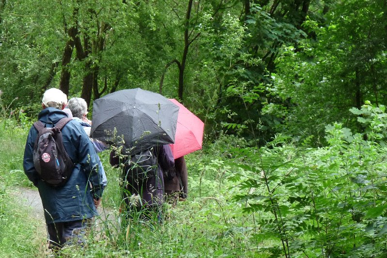
We Ripon Ramblers went off yesterday to walk a figure of 8. Park at Swinsty Reservoir, walk all the way round adjacent Fewston Reservoir, back to Swinsty again and walk round there. You can see from the pictures that the early promise of the day was not maintained. It rained and showered a lot. But rain and showers make for picturesque views.
An umbrella or two: the ideal accessory for an English walk.
A very rainy view.
Flowers of high summer at the lakeside.
Walking through the woods. A fine canopy against the rain.
Looking across Nidderdale.
Fewston reservoir.
Geese of all kinds populate the reservoirs in huge numbers.
Fishermen don’t seem to mind the weather.
Fewston just as the rain sets in.
A leaden sky.
Oh, and at the end, we took a small diversion to visit the old and picturesque village of Timble. It may seem like many a charming Yorkshire village, but it has a bit of extra history on the side, in the form of the Robinson Library. This building was the gift of Robinson Gill of New York, in 1892. He’d left Yorkshire in 1851 for America to seek his fortune. He found it: he had two successful stone yards on the Hudson River and was president of two New York banks.
His ancestors were prosperous yeoman who had lived in nearby Swinsty Hall, and he himself had been born and raised in Timble. From his adopted home in the States he arranged an endowment of £2000 to pay for a teacher for the school and for the upkeep of the building, and laid out £100 for books. The library provided the villagers with not only a library, but a free school, a Sunday school, a social centre and a reading room. The endowment failed with Robinson’s death: his descendents weren’t as astute about money as he had been, so the library fell on hard times for a while. The children now travel elsewhere for their schooling – after all, the village only has 100 inhabitants – but a recent programme to restore and re-invigorate the building means it is once more an active social centre for the community and beyond.
The Robinson Library, Timble. (Wikimedia Commons)
So, dear American readers, come and discover the area for yourselves, with its unexpected link to your part of the world. You could stay at the Timble Inn, an 18th century coaching inn, and then discover not only those reservoirs and their hidden history, but the towns, villages, dales and moorland of Nidderdale. You’ll be glad you did.
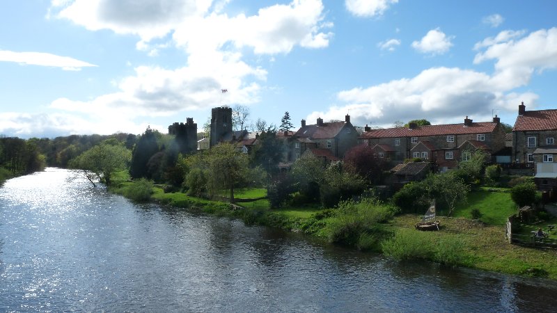
Not much more than a mile up the road is West Tanfield. It’s an ancient village that already existed when the Domesday Book was written in 1086. Its inhabitants might say though that the most recent chapter in its history was written only last year, when the Tour de France passed through the village. The Duke and Duchess of Cambridge dropped by in a helicopter to watch the riders hurtle down the hill from Masham, over the old bridge and on to Ripon. They took the time to walk through the village talking to as many people as they could. It’s a memory many locals treasure (I’m thinking of you, Penny!)
As you walk through the village yourself, you’ll notice a tower next to the 13th century parish church. That’s the Marmion Tower. It’s a 15th century gatehouse, and is all that is left of a vanished manor house that belonged to the Marmion family. As the direct line of this family ended, the succession passed first to the FitzHugh family, then the Parr family. You’ll have heard of them. William Parr was brother to Catherine, the sixth and last wife of King Henry VIII.
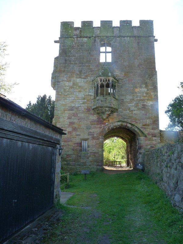
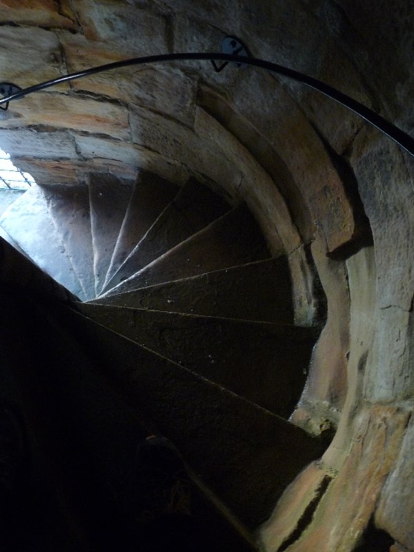
The Marmion Tower with its oriel window.That staircase.
It took me till yesterday to go and explore the remains of this tower. It might look like a castle, but there’s no evidence that it was ever designed to offer real protection. There’s no portcullis to the gatehouse, no narrow windows through which to loose offensive arrows. It’s a three-storey tower, which provided accommodation of reasonable comfort for the time, though the extremely narrow twisting staircase is a bit of a challenge. Although large, the rooms are domestic in scale. They offer splendid views over the River Ure and the fields and woods beyond, and on one side, over the village itself. One of the windows is a beauty in its own right. It’s an oriel window – a kind of bay window – projecting from the first floor of the tower.
The church seen from the tower
West Tanfield seen from the tower,
It’s ‘worth a detour’. And afterwards, you can go and sit in the gardens of the pub next door, the Bull, and relax over a drink in the picturesque surroundings of the river with the church and tower beyond.


You must be logged in to post a comment.