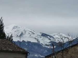
Rain, rain…….

The banner headline on this morning’s regional paper, La Dépêche du Midi, told us what we already knew.  There’s been twice as much rain this month as is usual.  Of snow, we’ve seen hardly a flake.

Driving back from Foix yesterday, we saw meadows that have become mini- lakes.  Even more fields glistened with water as the water table has risen to the very surface of the soil. It’s made the month a somewhat gloomy one, even though the days have been pretty mild.  The mountain peaks are snow-capped, as expected, but the white stuff barely creeps down the mountainside and with all the low cloud and zilch visibility, it’s sometimes hard to know where the Pyrenees have disappeared off to.

Our regular yomps into the countryside have been a bit curtailed.  Walk after walk has been rained off, and when we do go, we choose our routes with care.  If we don’t, we’ll be lugging kilos and kilos of glutinous heavy clay with us as it clings to our boots and the bottom of our trousers.
 

Boots - with added mud
Boots – with added mud

Roll on the 2nd of February, Chandeleur (Candlemas), the day when Winter decides whether to stick around or push off.  Last year, it was icily cold, and Winter stayed and made his presence felt with several weeks of constant snow, ice and bitter cold.  This year, he‘s looking much more half-hearted about it all.  We blame ourselves. We invested in snow-tyres and snow chains for the car.  We clothed our olive tree and a few other plants in white dresses of horticultural fleece.

Our olive tree all wrapped up for winter

So Winter laughed in our face.  We daren’t change the tyres or undress the tree though.  We all know what will happen if we do.

There's snow on them there 'ills: but not a lot.  As seen from our roof terrace
There’s snow on them there ‘ills: but not a lot. As seen from our roof terrace

Bugarach: ‘Doomsday Destination’

Cold.  Pale thin fog baffles the contours of the hillsides, and those of the distant castle at Coustassa.  Glimmering frost bristles the short maquis grass beneath our feet.  A watered lemony sun high above us attempts to burn winter away, and eventually does so.

That’s when we have our first view of Bugarach, the imposing thick-set mountain which dominates this part of the Aude, because it stands alone, rather than as part of a range, and today is pretty much thatched in snow.

Bugarach has been in the news for a while.  Here’s BBC’s ‘From our Own correspondent’ back in July 2011:

‘According to an ancient Mayan calendar, at some point towards the end of 2012, the world will come to an end.

It is not clear how that will happen, but apparently humanity does not stand a chance – except for those who seek shelter in the area surrounding Bugarach.

Just 200 people live there all year round, but doomsday believers and spiritual groups are convinced the village has magical powers, thanks to the local mountain – the Pic de Bugarach.

For years, rumours have circulated on the internet that extra-terrestrials live in the mountain, and come the apocalypse, the top will open and they will emerge with spaceships, and rescue the local inhabitants.’

Although it’s quite hard to entertain the idea that the mountain might be some sort of underground UFO car park, there are plenty of people who have done so, and with great fervour.  Here’s today’s Daily Mail, which has been talking to Jean-Pierre Delord, Mayor of the tiny village of Bugarach (pop. 176).

‘On Wednesday, he will close the village for five days to anyone who doesn’t live here or isn’t already booked to stay, and draft in hundreds of police, military, firemen and Red Cross to ban any gatherings, shut off the mountain and arrest anyone silly enough to try flying over it.

‘What if tens of thousands of people turn up?’ he says, throwing his arms up in the air. ‘I have no way of knowing what will happen. I have no crystal ball! I don’t care if people want to chant naked or talk to the trees, but I have to protect my villagers. I am responsible for them.’’

He’s not over-reacting.  Local house-owners have been able to rent out their homes for the period in question for astronomical prices, and even camping spots are going for 400 euros a night.  For most locals though, the whole thing is at best a nuisance, at worst a real headache.  The nearer we get to December 21st, the more people descend on the area, and the police and army are already involved in keeping order.

We enjoyed our views of Bugarach, as ever.  We spent time pretending to look for UFOs and generally mocking the New-Agers who are so convinced by the end of the world as we know it.  Then we got on with the business of enjoying our walk in the here-and-now.  Here are some photos of our day.

A very English Sunday walk

If you go on a walk near Limoux in the Aude at this time of year, you’re entitled to scenery like this:

Vineyards near Villar -St-Anselme

In our walking group here in Laroque we all take turns to organise the weekly outings.  And this week, it was the two of us, the only English, who were in charge. We decided on an autumn walk among the vines round Saint Polycarpe, near Limoux.  The weather forecast wasn’t great, but the rain promised to hold off till 3 o’clock.  But no.  English leaders, English weather. Think of us plodding through the mud as the rain increased in intensity, long long before 3 o’clock arrived.  Everyone blamed us, of course.  They think this is the only kind of weather we know, back in England.

It all began so well….

Above Saint Polycarpe, 10.00 this morning.

Lunch was early, at Gardie, but we didn’t beat the rain.  We had our break in the bus shelter, for goodness sake, and got togged up like this immediately after.

The clouds descend…..

And the gloom.

Can’t see much.

Saint Polycarpe’s down there somewhere…

Still, nobody complained.  We got our fresh air and exercise, and our friends had a thoroughly good time holding us responsible for the rain and mud.

PS.  Dangermouse update.  We caught him last week.  He is no more.  He was a rat.  Eurghhhhh.

The tragic and savage history of l’étang d’Izourt

The drive to the start of the walk was dramatic enough.  Forested and craggy, our narrow road out of Auzat switch-backed steeply up the slopes in a seemingly endless series of hairpin bends.

And our walk began, an 1800 foot climb, upwards through forest then out onto the stony, rocky path towards the man-made étang d’Izourt, one of the many reservoirs in the area maintained by EDF to provide power. Once, a helicopter flew over.  Since there are no roads up there,  it was delivering either men or supplies to a team we could see labouring on a more distant slope.

The walk changed for me as I learnt the story of what had happened back in 1939 when the reservoir was being built.  Most of the members of the construction team at that time were economic migrants, Italians from the Veneto, and whilst working there, they lived in huts on site.

The weather conditions had already been atrocious for days when on March 24th 1939, a fierce blizzard struck.  There was no option for the workers but to hole up in their huts.  The storm was so fierce that huts B and C were destroyed from the weight of snow above, and the roof from hut A blew off.  The desperate men sought both to escape and to try to help their work mates, many of whom had died or been gravely injured by the tumbling buildings.  A nearby avalanche brought down the cable car linking the site with the works below.  The only way up was on foot, and rescue attempts were pretty much futile, though bodies and the injured were recovered as management attempted to evacuate the entire area.  On 28th March, a team of army skiers managed to get through and working into the night, brought down the remaining bodies and wounded.  31 men, 29 Italians and 2 French, were buried at the cemetery in Vicdessos on 31st March.  There they remain, as the families in Italy were too poor to manage the expense of repatriating the corpses.  The memorials at the lakeside are still the site of pilgrimage, thanks to the efforts of the ‘Ricordate-Izourt’ Association: locals and Italians who honour the memory of those lost workers.

We ourselves had started our walk in bright sunlight.   Spots of rain began.  Then the wind.  By the time we reached the lake, there were times when the gusts felt almost horizontal, and we struggled to find protection from the rocks to eat our lunch.  The more modern huts now on site have their roofs held on by strong metal cables, and we could understand why.

The sky turned the colour of lead, and we rejected the idea of exploring the lake in favour of hurrying down the way we had come.  We knew we’d be OK, but we also know to treat the mountains seriously and with respect – conditions can change very quickly.  We were fine of course, but that fierce wind on a warm October day gave us the smallest hint of what things could be like if you were trapped there in much nastier conditions.  Even now, the most efficient way of supporting the workers still on site from time to time is to get them and their supplies there by helicopter.  A noisy chopper whirled up and down the mountainside several times as we walked down, our journey cheered by a rainbow linking our mountain with the one next door.  Though we were sorry the weather had chased us home, we were grateful  not to have been exposed to  the dangers the mountains can offer from time to time.

This slideshow requires JavaScript.

In search of a druid – or a trout

Mont d’Olmes: local playground for skiers.  You wouldn’t travel any great distance to spend a holiday here, but for locals, it’s the ideal winter sports spot.  It’s a wonderful area for walkers too.  We’ve only just begun to discover the wealth of footpaths, mainly across truly ‘sauvage’ slopes, with views downwards to Montségur, Roquefixade, and northwards almost, it seems, as far as Toulouse.

It’s alright waxing lyrical though.  For many people living in the area many years past, and until the early years of the 20th century, these slopes were the places where they came for long hours each day, working both on the surface and by crawling through narrow airless tunnels, mining talc.

Talc?  Yes, that stuff you sprinkle on babies’ bottoms.  That stuff those Olympic gymnasts plunge their hands into before taking to an overhead bar.  That stuff that apparently still has many industrial uses, notably in the ceramics industry and for plastics paints and coatings.  This soft soapstone was found here on Mont d’Olmes and is still mined in nearby Luzenac.  Here though, all that is left are the gashes in the mountainside where the workings once were, and a few ancient trucks once used to transport the material down to civilisation.

Come and take the path we took last Sunday.  We walked in more or less a straight line, up and down hill after hill, as the path became increasingly rocky and impassable.  Our reward was the occasional handful of raspberries or bilberries, then a lunchtime picnic by l’étang des Druides.  No, sorry, l’étang des Truites.  Whatever.  Nobody seems to know which name is correct.  Some say the person making the first map of the area misheard and wrote ‘truite’ – trout – instead of ‘druide’.  We saw no trout.  We definitely saw no druids.  But we had a jolly nice picnic.  And I paddled.  And then ruined a perfectly good day, in which morning chill and mist had given over to hot sunshine, by falling flat against the rocky path, cutting open my face and chipping three teeth.  I hope the druids weren’t lining me up for some kind of sacrifice.

This slideshow requires JavaScript.

A Mediaeval picnic

Montségur in the morning mist

Saturday morning dawned damp and misty. This was fine by the 100 or so walkers who gathered bright and early in Lavelanet for the annual Marche du Tisserand. The walk, organised by the town’s Musée du Textile, celebrates the ancient ‘chemin pavé’ used by the cloth workers who lived in Montségur and walked this path to bring their produce down to Lavelanet to be sold. Saturday’s walk, the 27th, was for fun, and nobody would have had more than a light rucksack to carry. The full three hour trek (6 hours both ways of course), steep and stony at times, when laden with goods to sell one way and perhaps provisions for the household the other must have been a slightly different matter.

This time too, there were goodies at the top for the walkers as they finished their ascent. The mayor of Montségur was there with an aperitif for everyone, and we at Découverte de Terres Lointaines were there too, with a mediaeval picnic we’d been preparing .

Who knew chopping coriander could be such fun?

The cooking took several days, but the research, with the help of the Museum at Montségur, took weeks of researching, testing, tasting, rejecting, trying again… Still, eating’s always fun

Though curious, the walkers were suspicious too. What would a mediaeval picnic be like? Heavy, probably, with mountains of flatulence-inducing beans. Tasteless too maybe.

What a surprise then. Here’s the menu:

Spinach tart with lardons: we could have used nettles or any of a whole range of herbs, but settled on the more widely available vegetable option.

Poichichade: this herby chick pea paté, which we served on hunks of organic wholemeal bread, is a close cousin of hummus, but without the tahini. It went down well.

Broussade:  star of the show! A very tasty mix of smoked fish and curd cheeses. This really is one for anybody’s dinner table. Simple too. Recipe below.

Pets de nonne: basically deep fried choux pastry, puffy and light. Here’s the story. Back in the Middle Ages, the bishop of Tours was visiting the Abbey of Marmoutiers to bless a relic. Whilst preparing a meal in his honour, a novice let fly an unfortunate noise of the kind familiar to those of us who’ve eaten far too many beans. To cover her embarrassment, she busied herself dropping the choux paste she’d been making into some handy cooking oil so that it sizzled loudly. The pets de nonne were born.

Fromentée sucrée:  cracked wheat cooked with milk and honey. If you like rice pudding, you’d like this too

Gâteau de fruits secs:  a rich and heavily fruited pain d’epices style cake.

Just before the walkers arrived: The picnic on its thoroughly modern paper plates.

The congratulations when they came – and they came in quantity – were tinted with some astonishment:  ‘It was so good. We never expected it to be so tasty! Well done’.

But after eating, drinking and lots of talking, it was time to dance. Zingazanga had been playing loudly throughout the meal, but they turned their attention to teaching us simple steps and dances from centuries ago. Even I with my two left feet joined in.

Let the dancing begin

Broussade

Ingredients
• A quantity of as many varieties of smoked fish as you can decently lay your hands on: we used smoked salmon, herring and haddock.
• A more-or less equal quantity of brousse. This is a curd cheese made from the milk of sheep, goats or cows. A mixture would be ideal, and failing that, any soft curd cheese.

Broussade in the making

• Paprika
• Chopped dill
• Seasoning.

Process half the fish coarsely, and finely chop the rest. Mix with the other ingredients. That’s all. Enjoy with some good bread and a probably thoroughly un-mediaeval green salad.

‘East, west, home’s best’

When guests come to stay, Malcolm and I often pore over maps looking for some unexplored – by us – corner of our patch.  But in the end, what’s the point?  Our visitors aren’t sickly pale wraiths whose jaded walking appetites have to be tempted by novelty.  They’re happy with the solid day-to-day fare just a mile or two down the road. To them, in any case, everything is new.

We too are happy to revisit favourite walks.  They’re never the same.  The changing seasons bring different flowers, different cloud formations.   Mountains which perhaps were sparkling bluish-white last time we visited, turn green and purple towards summertime with just the odd small patch of snow near their summits.

Today, then, we went with Christine to visit our old friend Roquefixade, just a few miles away.  A steady climb through the juniper-scented woods and along a rocky ridge leads to a ruined château, once far above us, now somewhat below. Here it is.  Enjoy the views.  We did.

Capital Capitelles

The first capitelle on our walk

We’ve been walking north of Carcassonne today, with our friends Barbara and Tim, holidaying in the Aude from North Yorkshire.  When we decided to go and explore the curious stone huts called capitelles in the scrubby garrigue near Conques sur Orbiel, we assumed they were something like the orris of the Ariège.  These too are small sturdy dry stone wall huts: but orris were used by upland shepherds.

The dry stone walls of the capitelles

Capitelles are quite different.  Following the formation of France’s Second Republic in 1848, everyone wanted something to call their own.  Here in Conques, the poorest members of society looked beyond the village where they lived for some way of acquiring a bit of land  and earning some extra money. They realised that the dry impoverished soils of the garrigue were good for only one crop: vines.  As the peasants started to work the land to plant their vines, they dug up stones – hundreds of stones.  And they used them in the first place to make low stone walls marking the limit of their territory.

That south-facing door’s not very big

After that they built small huts to shelter from bad weather.  These round or square huts are in the form of a dry stone wall rising to a semi-circular vaulted roof also in stone: no mortar, no foundations, a bare earthed-floor and a single small door, always facing south.  They were all built by1880 or so, and the peasants who built the huts and worked the land here would have done so in any spare time left from their ‘day jobs’ as farm labourers.  And this continued till the Fist World War.  Men left to become soldiers, and at much the same time phylloxera struck.  This double blow meant the area returned to uncultivated garrigue, and only recently have the capitelles been restored.  They add interest to a stony landscape characterised by scrubby vegetation, low trees and shrubs and bright ground-hugging summer flowers.  I’d have said distant views of the Pyrenees too, but today was misty and overcast, so Barbara and Tim had to take our word for it.

Close up of a carefully constructed roof

Above us only skylarks

Every Thursday, Anny leads us on a walk. We might go eastwards to the Aude, south towards the higher  Pyrénées….or indeed travel in any direction, certain of a wonderful day’s walking.

Today we met just beyond Foix, and still in our cars, climbed…and climbed…and climbed,  steadily for 9 miles.  And at the highest point of the Col d’Uscla (1260 metres), we parked. Then we laced up our walking boots, slipped on our rucksacks, and climbed…and climbed…. and climbed.

It was steady rather than challenging, and several times, Malcolm and I remarked that if it were not for the  Pyrénées beyond, we could have been on the North York Moors, with added altitude and sunshine.  Endless expanses of bilberry plants added to the illusion. Each hill we climbed promised to be the last: but as we reached each summit, another hillside appeared in view.

Our eventual reward was at the Cap-du-Carmil, at 1617 metres, with a 360 degree panorama of the  Pyrénées. It was quite, but not perfectly clear, yet we could probably see 50 miles or more in any direction. The only sounds were from the skylarks, joyfully singing way above our heads. I’ll let my pictures tell, slightly inadequately, the story.

Down through more wooded paths, there was the town of Massat below. Once the Ariège’s largest town, its isolated position and failing industrial life means it’s slightly forlorn now.  But not when you’re looking down on it, several hundred feet below.

A quick sortie to the Tour Lafont. This was built in the 1830’s, at a time when 12,000 French soldiers descended on the area to fight the ‘demoiselles’, local guerrillas disguised for some reason as women, determined to maintain their rights to collect wood for fuel, rather then allow it to be taken for the industrial economy slowly emerging throughout France. Despite their superior numbers, the soldiers lost the battles, and there are only odd reminders of their presence at the time in towers such as this one.

After lunch, on through the woods, until we rejoined once more our path with its open mountain views. Horses grazed the short grasses, and seemed only mildly curious about us.

And then it was over.  Boots and rucksacks off: cold juice, a moist and squidgy chocolate cake (thanks, Anny!), a final chat…. and back down that narrow uninhabited 9 mile road to civilisation , home and a cool shower.

A ruined castle above spring flowers

We ‘do’ ruined castles here in this part of France.  And last Sunday we Laroquais from the walking group ‘did’ one that was new to us.

We went off to the Aude, near Rennes-le-Château, for a long morning’s march and a final energetic upward scramble to Bézu and the few castle ruins that are left there.

I was going to tell their story.  But then I found another blog to do the job for me.  Follow the link!  Some of the research here has been fostered by the – to me – unaccountable interest in Dan Brown’s books, but the page on Bézu is mercifully free of his influence.

I’d sooner simply share some of the photos of the day, many of them of the flowers we saw.  May, as in much of Europe, is a glorious time for them.  The dry, thin soil of this part of the Aude nourishes small, bright ground hugging plants: they show themselves off perfectly against a backdrop of alternately red and rather white earth.

I’m going to go on being lazy today.  If you can name the flowers so I don’t have to, I’d love to hear from you.

This slideshow requires JavaScript.