Back in England, it’s time to dust down our walking boots again. As we stepped out today, on a beautifully fresh and clear early Autumn morning, we contrasted our walk from nearby Masham with hikes we’d gone on in Korea.
It was the weather we noticed first. Probably it’s colder there now too, but then, we wore t shirts and battled against the humidity. We wore fleeces today. We tramped through fungus-laden woodland in both countries. Here though, as we glanced at the tussocky meadowland near the River Ure, we saw sheep, sometimes cattle . There, valley floors were terraced with paddy fields, citric green with young rice.
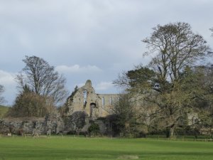
Here, there were distant views of solid stone barns and farmhouses – even a country house, Clifton Castle. There, we were more likely to come upon a hidden Buddhist temple, its solid, yet graceful wooden form painted cinnabar, blue-green, white, yellow and black.
In Korea, woodland in the countryside is dominant once you get away from ‘civilisation’. Here, we drifted between woods, meadows, ploughed fields and ground by the open river .
We enjoyed the lot. But today, we appreciated saying ‘hello’ again to our familiar local landscape.
Here in England, we’ve got a bit of a thing about images of a white horse cut into the hillside. There are well over 20 of them, from the South Downs to Wiltshire, via Leicestershire and even as far north as Tyneside. We like to think many of them are pretty ancient, like this one, the Uffington White Horse, first carved into the hillside chalk of Oxfordshire: probably in the Iron Age, possibly as long ago as 800 BC. But they’re not. Most of them date from the 17th, 18th and 19th centuries.
Uffington White Horse (Wikimedia Commons)
We’ve got our own white horse here in North Yorkshire, near Kilburn. It’s really rather modern. Back in 1857, a Kilburn-born man, Thomas Taylor, who’d become a provision merchant down in London thought that his home village should have its very own version of the Uffington White Horse. He got John Hodgson, who was the local schoolmaster, together with the schoolchildren and a band of volunteers to cut a horse shape from the turf to reveal the sandstone beneath. Six tons of lime were used to whiten the image, which can be seen from many vantage points in North Yorkshire, and on a clear day, from as far away as Leeds, 45 miles away, and even North Lincolnshire.
Kilburn White Horse (Wikimedia Commons)
And that’s where we went yesterday for an energetic nine mile walk. Our path took us along scenic Beacon Banks. Once it had a beacon at its summit to alert the country when danger threatened. It warned of the approach of the Spanish Armada in 1588. It was a watching point for the Home Guard during World War II. Now it’s simply a lovely place from which to survey the countryside. Our route took us past three of the prettiest villages in this part of the world – Coxwold, Husthwaite and Kilburn – through woodland, through farmland with views across to the Vale of York, the Hambleton Hills and North York Moors, passing ancient Norman churches we couldn’t call into because it was Sunday. And the White Horse – often there as a backdrop to the scenery. Here are some picture postcards of our day.
Old Grange Road, Jarrow, c. 19502(?) (geordstoree.com)
What image comes into your head when you think of Jarrow? If, like me, you’ve only really heard of it in the context of the Jarrow March, it may be a depressing one. Grimy desolate streets, a down-trodden and abandoned population, with little hope of change for the better maybe.
Well, Robert Colls, who walked with us on our Jarrow March Mark 2 for ‘Ramblings’ won’t entertain such images He’s irritated by those commentators, often from the south, who see nothing but the negative. He could do without the likes of George Orwell painting such depressing, hopeless images about the Industrial North. He was raised in nearby South Shields. His memories of the town are of a place that was gritty, maybe dingy, but where there was a rich cultural life, and a warm and supportive community where it was good to grow up.
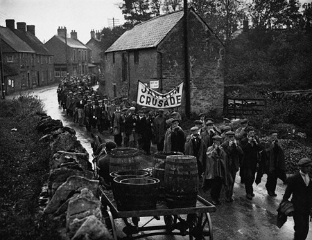
Jarrow, in the North East of England, had been dependant on shipbuilding since the 1850s, but demand for ships fell throughout the 1920s and became worse during the 1930s. The main shipyard, Palmers, once the source of Jarrow’s prosperity, closed in 1934 after years of steady decline . By 1936, there was 70% unemployment in the town.
HMS Duchess, the last ship to be launched from Palmer’s shipyard, July 1932 (Imperial War Museum)
Town councillors planned a march to London to present a petition to Parliament highlighting the desperate conditions in Jarrow and towns like it. They secured cross-party support. They involved local churches and the business community. They fund-raised. Socialist medical students volunteered to work as medical attendants along the route. Nobody in town wanted yet another communist-inspired ‘hunger march’. No, Jarrow people planned a respectable event, one that would win widespread support.
It rained on and off the day we walked last week. I suggested to Robert that those marchers, with shabby, worn-out clothes would have had a thin time of it. I was wrong. The organisers insisted the men who were chosen to march – and yes, they were chosen – should wear their ‘Sunday best’, look smart and conduct themselves well. They had medicals, and only the 200 fittest men were chosen to march, accompanied by a second-hand bus carrying cooking equipment and ground sheets. A successful fund-raising campaign ensured the march was well-prepared and equipped, and that the men had a little pocket-money.
They started marching at 8.30 each morning of their 25-day journey (with Sundays as rest days). Many marched army style – 50 minutes to the hour with 10 minutes’ rest. A mouth organ band was a great success, ‘keeping the men swinging along all the time’, according to a report in the Shields Gazette, and there was singing – led sometimes by Ellen Wilkinson. Local papers apart, the only national paper to give the Jarrow Crusade wide coverage was The Manchester Guardian. Copy was supplied by the journalist Peter Richie-Calder, who walked much of the way with them.
Photograph of J McCauley, a Jarrow marcher, singing to his co-marchers on their walk to London, taken in October 1936 by Edward G Malindine for the Daily Herald. The caption read ”Croonin’ J McCauley, who helps to keep his co-marchers’ spirits high, has been out of work for 5 years’ (National Media Museum)Ellen Wilkinson, by Elliott & Fry, 4 June 1940 (Wikimedia Commons)
Ellen Wilkinson was one of only four women MPs at the time, and she represented Jarrow. Though from a poor background, she was well-educated – she won a scholarship to Manchester University – and built up an impressive career both in the unions and in parliament. By the age of 24 she was already National Women’s Organiser for the Cooperative Employees union, and only nine years later, an MP – one of only four women in parliament. She was a terrific orator, she was passionate, and she believed in the Jarrow marchers and their cause. She walked with them whenever she could, distinctive with her fiery red hair. Towards the end of the march, Ellen broke away in order to address the Labour party conference and, with tears streaming down her face, exhorted delegates to ‘…tell the government our people shall not starve!’ She failed, however, to win special attention for her cause.
Ellen Wilkinson addresses the Jarrow Marchers (History Today)
The lack of political affiliation helped those marchers. They were fed and watered and given places to sleep all along their route. Harrogate, for instance, just south of Ripley, then as now is a true blue and prosperous sort of place. But the civic authorities greeted them warmly, the Rotary Club fed them, and they were given sleeping quarters by the Territorial Army.
Jarrow March (BBC)
I depend on good boots when I’m walking and wondered about how the marchers were shod. They had decent shoes, Robert said. And what’s more, when they arrived in Leicester, the Cooperative Society’s bootmakers stayed up all night to repair all their by now thin-soled shoes, and did so without pay. The story of the Jarrow march is peppered with such examples of support and kindness.
Ellen Wilkinson marches with the men (Fox Photos)
They arrived in London. They presented their petition in Parliament, the petition that had 11,00 signatures. It prompted only the briefest and most complacent of discussions. And that was that. The disillusioned marchers returned to Jarrow by train, their fares paid by benefactors.
Astonishingly, many men finished the march healthier than when they had started. Boosted by regular exercise – and the decent food and accommodation they had received along the route – many put on weight. This was just as well. For the duration of the march, their unemployment benefit had been suspended as they were ‘unavailable for work’.
A few modest attempts to bring work to the town resulted in jobs for a few hundred people, but only with the start of World War II did work once more surge back into the shipyards and factories of Jarrow. For the duration only.
Ellen Wilkinson continue to be a thorn in the side of the Labour party, though she worked tirelessly at home and abroad against fascism. Perhaps her greatest achievement was in 1945, when as Minister for Education in the Labour Government, she was instrumental in having the school-leaving age raised to 15. No wonder Helen is an enthusiast for this most dynamic, charismatic and troublesome woman.
So there we are. One – no two – history lessons, all parcelled up in an agreeable package of a long country walk, following, if not exactly by the same route, in the footsteps of those Jarrow Marchers.
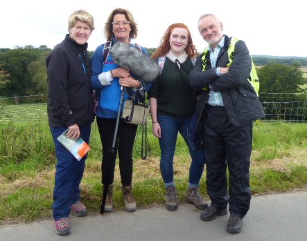
Clare Balding, Lucy Lunt, Helen Antrobus and Robert Colls in the steps of the Jarrow Marchers.
Clare, Lucy, Helen and Robert pose for a group photo. None of us asked for selfies-with-Clare
I came in the other day to find a message on the answer phone. The BBC. Clare Balding wanted to talk to me. Well, not Clare actually. She’s one of Britain’s favourite broadcasters and a bit busy I dare say. Her research assistant Lucy finally got hold of me, and asked me if I’d be able to lead Clare and team on a walk from Ripon to Ripley for ‘Ramblings’, a popular programme on BBC R4 about walking.
Why me? Because I’m Hon. Sec. of Ripon Ramblers, our local walking group, and our details are out there, if you care to look. Yes, but why ME? Lucy thought, after our chat, that I’d be OK on the radio.
OK then, why Ripon? Because, it turns out that in October 1936 the Jarrow Marchers walked from Jarrow, through Ripon to Ripley and beyond, all 280 miles to London. In October, ‘Ramblings’ plans to broadcast a programme to celebrate its 60th anniversary.
Perhaps you don’t know much about the Jarrow March. Neither did I. Not till I met Clare and Lucy, cultural historian Robert Colls, and Helen Antrobus, who’s a real Ellen Wilkinson enthusiast from the People’s Museum in Manchester. The five us walked and talked our way along our eight mile route from Ripon to Ripley, and we barely noticed the rain which threatened constantly, but only delivered occasional short sharp showers.
This is a blog in two parts. The first is our country walk, the second about the Jarrow March. But Friday wasn’t in two parts. Every step we took, we remembered those marchers. Robert and Helen told us the story. Together, we drew comparisons between their march and our own hike.
I’d already dutifully planned and walked a route. The marchers went entirely on main roads, but if you’ve ever driven on the A61, you’ll know this is no longer a good idea. Country paths were the way to go.
‘Do we go this way?’ Lucy records Clare getting directions.
As we set out together from Ripon, we got our instructions. Lucy had her furry-muff-on-a-stick. You’ll have seen those, as reporters rove round town centres talking to likely passers-by about some event that’s happened locally. When recording, Clare’s always on the right of the person she’s talking to, and Lucy’s there on the left with her recording gear. It was slightly odd to walk alongside Clare as she formally introduced to the programme, telling listeners where she was, why she was there, and who we all were. But soon we forgot about that muff. We all chatted together easily, about that March, about walking, about each other. Sometimes we had to repeat what we’d said, in a spontaneous ‘I’ve just thought of this’ kind of way, because some passing noise – RAF jets overhead for instance – had ruined the recording.
This was the scenery of the early part of the walk.
In many ways our walk was a scam. The A61 passes through rolling hillsides, productive farmland, cows in the pasture, and pretty villages. It’s all bucolic England at its best. Our route presented a more hidden countryside. Isolated farmhouses with dilapidated barn roofs, ancient pastures, secret dark, damp woodlands, and tiny rather remote hamlets.
If it survives the cut, you’ll hear Clare painting a word-portrait of this farmhouse during the programmme.
At first though, we were on a road. Badly maintained, rather narrow and with tall hedges it’s a bridle path these days, but it is still tarmacced, and perhaps the kind of highway those marchers would have recognised. Later, on grass-trodden pathways, we passed Markenfield Hall, a 14th century moated country house.
We saw Markenfield Hall nearby as we walked. The Jarrow marchers didn’t.
Those marchers didn’t. We went through the village of Markington. Apparently the marchers were welcomed here too, though we couldn’t imagine why. It’s more than a mile or so from the main road and history doesn’t record why exactly they made a detour. We strode along the edges of barley fields, on woodland paths and across gorsey heath, all without meeting a soul. Not what the marchers experienced.
This is farming country.
And we talked. That’s what I’ll remember most. The sheer pleasure of walking and talking with a group of people thrust together for the day who quickly found themselves to be friends – just for a day. Thanks you Clare, Lucy, Robert and Helen for a very special occasion. It was a real privilege.
Clare strides away into the woods.
And the Jarrow March? More about that in my next post.
We went for a walk from Leighton Reservoir this week. It’s in many ways a bleak, bare, sometimes boggy landscape, and this suited our mood in a bleak, bare post-Brexit week. The view is softened at the edges by the rolling, green, stone wall-skirted Yorkshire Dales which lie beyond the heathery moors.
But look what we found as we consulted our Ordnance Survey map. These were the places we passed, or could see at a distance:
Sourmire Moor
Gollinglith
Baldcar Head
Jenny Twigg and her daughter Tib (Two natural stone stacks towering out of this boggy moorland landscape. We didn’t get as near to them as we’d have liked this time)
Grewelthorpe Moor
Benjy Guide
Sievey Hill
Horse Helks
Cat Hole
Jenny Twigg and her daughter Tib (Wikimedia Commons)
Really, where else could we be but Yorkshire?
Postscript: Just at the end we met this little chap, a just-fledged thrush. We hope he (she?)’s ok, because he just about managed to fly rather stumblingly off to a safer place than the track where we spotted him.
This was a fine day for a walk, and a fine day to have a few history lessons thrown in
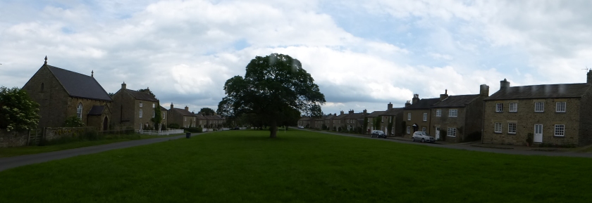
This is what we did. Here’s our starting point at East Witton, about 15 miles from home. It’s a lovely small village of about 250 people, where most of the houses were built in the early 19th century round the extensive village green.
East Witton
We passed through fields with views across the Dales. We walked along a green lane, through woods, and eventually reached a wooded gorge through which the River Cover runs, and where we crossed over the charming stone bridge known as the Hullo Bridge. It was quite a climb up the hill on the other side, and we were hoping for glimpses of Braithwaite Hall. Too many trees in full leaf. We hardly glimpsed it.
It’s built on the site of a grange belonging to Jervaulx Abbey. After the Dissolution of the Monasteries it continued as a sheep farm, as it had been under the monks. This is an area where the monks of both Jervaulx and Fountains Abbey extended their influence widely: enormous numbers of sheepall over the region were managed from local granges where the lay brothers who cared for them lived.
The ruins of Middleham Castle.
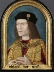
We were nearly in Middleham now. This is above all a horsey town. The monks of Jervaulx bred horses, and brought them to the Moor to exercise them. When the monks eventually went, the horses remained, as did the training tradition . Middleham these days is home to around 15 racehorse trainers and 500 horses, yet it’s a small town of hardly more than 820 people. It was too late for us to see the horses out on the Gallops this morning, so instead the first thing we saw was the castle, which dates back to 1190 and was the stronghold of the powerful Neville family from the 14th century. Richard Plantagenet, later Richard III was sent here as a young man to be trained in arms by Richard Neville, Earl of Warwick, his cousin.
The earliest known portrait of Richard III (Wikimedia Commons)
Warwick had the bad habit of changing sides throughout the Wars of the Roses (1455-1485) depending on whether the Yorkists or Lancastrians had the upper hand. Eventually he came to a bad end when he was killed by the Yorkist King Edward IV and his younger brother Richard. Edward gave Middleham Castle, and much else to Richard who lived there with his wife, virtually ruling the North of England, for 11 years. When Edward died, Richard seized the throne and reigned for only 2 years before dying in August 1485 in the final battle of the Wars of the Roses, the Battle of Bosworth in Leicestershire. And there his body remained for 517 years, before being exhumed from a car park in Leicester in 2012.
For us, Middleham was the site for a rather good picnic, followed by a visit to a teashop for an indifferent cup of tea, and even more indifferent cake. But the calories were useful. There were stiles to cross into fields deep in cut grass, waiting to dry off into hay: a fine walled track Straight Lane – to walk along before reaching the River Cover, languidly passing over bleached white stones on its way to meet the River Ure. We briefly touched the road once more as we passed Coverbridge Inn. This dates from 1684, and was owned by the same family – the Towlers – till 1930. Local legend has it that when the monks of Jervaulx were forced to disband in 1537 at the Dissolution of the Monasteries, they shared their secret recipe for Wensleydale cheese with the Towlers. We shall never know.
A final walk along woodland paths, open farmland, fields enclosed by characterful drystone walling and we were back in East Witton. A grand day.
It was my turn to lead a walk on Tuesday. I chose Coverdale. Here’s why.
The River Cover, which gives the dale its name, wanders through an isolated corner of Wensleydale. Here you’ll find hamlets with intriguing names like Swineside, Horsehouse and Gammersgill, a few abandoned leadworkings, a great many sheep, and not much else. The principal settlement, Carlton, has 230 inhabitants and the main – the only – road to it is mainly single track. This is where we began our walk.
Here were hillsides, close-cropped by sheep. Here were ancient terraced field patterns showing that the area, even if lightly-populated now, has long been settled by farming communities. Here were narrow steep-sided gills sheltered by glades of trees. It offered a walk full of variety.
Sheep with her lambs.
We yomped up and across meadows populated by those sheep and their curious, always hungry lambs, enjoying long-distance view across the fells. Curlews called above us.
Curlew – Wikimedia Commons
We climbed over wooden stiles, stone stiles, ladder stiles and through narrow-gap-in-the -stones-stiles. As we passed though woodland we sniffed the slightly acrid but appetising tang of early wild garlic.
Our coffee-stop view across the valley. Those stone barns are typical of Wensleydale and Coverdale.
Soon we could see our half-way point on the other side of the valley. Horsehouse these days is a tiny collection of isolated homes. But it gets its name from the days when it was a really important staging post for those making the long journey from the north (even as far away as Edinburgh) to the south (London?).
And once we’d crossed the River Cover, we were in woodland again. We found a grassy bank, complete with bluebells, tree trunks to sit on, fat white pebbles for the waters to tumble over: perfect comfort, perfect peace.
We had a young German guest, Felicia, with us for the day. You can see she’s 40 years younger than the rest of us. She’s climbing trees after the picnic.
After lunch, curlews gave place to oystercatchers, with their smart black and white plumage and vivid orange beaks.
Oystercatcher – Wikimedia Commons.
And then we came to the point in the walk where the instructions read ‘Turn left at the last stile’. How mystifying. How can you possibly know which the last stile is till you’ve passed way beyond it and not found another? Ever-resourceful we found our way anyway, strode through Gammersgill, across a few final fields, and got to journey’s end not long before the day’s sunny warmth gave way to wind and showers.
The story is – there is no story to tell about our walk near East Witton.
It was cold, frosty but bright so we stepped out energetically. The day went on to be warm, breezy and sunny. There was only one stile to climb over. The ground was firm and frosty, but neither icy nor muddy. Nobody slipped or fell over or got injured.
The landscape was just right. The gently undulating farmland of the Yorkshire Dales gave way to moorland whose picturesque bleakness was enhanced by the occasional lonely tree. We’d pause to take in the long-distance views across the Dales. And as we returned through woodland to East Witton once more, there was a proper English parish church just asking to be photographed. Nobody was displeased by the views.
Our two pauses were ideal. Mid morning, we had picture-postcard moorland views in front of us, and the solid protection of a sturdy drystone wall behind. We ate our lunchtime sandwiches in sheltered bosky woodland, with convenient benches in the form of tree trunks. Nobody got cold, or wet, or lost their sandwiches.
The energetic uphill stretches were all before lunch. Our path afterwards returned us gently to the valley floor. So we got back to base after a gently-challenging workout. Nobody was exhausted or fed up.
So there’s nothing at all to tell you.
Oh hang on. This will have to serve as our banner news headline. ‘Hiker loses gloves on Wensleydale walk’. That was me. First one glove vanished, then the other. But as anyone who knows me will tell you, this is not news at all. It’s what I do most weeks during the winter.
I first walked from Jervaulx to Jervaulx last April, and wrote about it here. However, I failed to lead my fellow ramblers along the same route later that month as I’d said I would, because it rained…. and rained. I’d promised them the walk though, and today was the day: bright, sunny, blustery – a perfect winter hike. Except for one thing. Those floods that have dominated British news this winter are still making their presence felt.
The ruins of Jervaulx.
Our route today didn’t take us through pastureland. Sheep aren’t very good at being knee-deep in mud. It took us through soggy fields, and past lake after lake after lake: waters that simply were not there last time I took this route. It was all very pretty. Less pretty was the scene at stiles. Look at us skidding and sliding, trying to pick the shallower puddles as we waited out turn to get from one field to another.
We’re British though, always plucky in adversity. We soldiered on, sometimes a little weary of heaving mud-crusted boots along sticky, sludgy paths. But nobody fell over, nobody lost their sandwiches in the mud. Everybody enjoyed those vistas over the Dales, the starkly beautiful skeletal outlines of winter trees, the blue skies, dappled with characterful cloud. Were we glad to have made the effort? Well, I was, and I think my steadfast and dependable companions were too.


You must be logged in to post a comment.