On Christmas day I posted a scene from our days living in the Ariège. I felt very nostalgic for the Pyrenees, for snowy peaks silhouetted against clear blue skies, for cold clear air.
Today gave me the chance to remember that our countryside, though so very different, has its own charms and pleasures. We walked from nearby Masham and past the gravel pits of Marfield, now home to water birds of every kind: though only Canada geese and a few proud swans got a look in this morning.
We passed stands of ancient oaks, saw stark lines of skeletal trees marching along the horizon, watched the sky turn from Pyreneen blue to moody grey and purple then back to cheerful blue again. Sheep in late pregnancy cropped the short grass. We stopped to chat with fellow walkers walking off a calorie-laden Christmas. The River Ure was never far away. A pretty good morning’s work, actually.
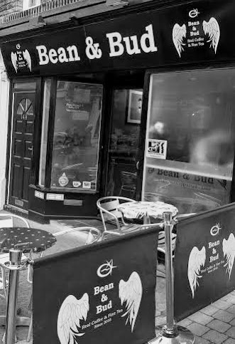
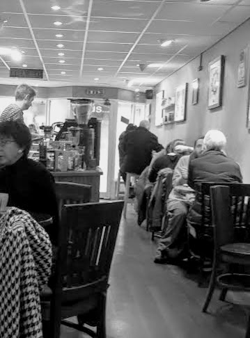
We love Bean and Bud. Without a visit to this coffee (and tea) shop, no visit to Harrogate is complete. It’s a compact and friendly place, on a busy little street filled only with small independent and charity shops.
Bean and Bud sets the gold standard by which all cups of coffee should be judged. Choose between one of their two weekly featured beans – or something else if you prefer – and your coffee will never be churned out, just because they’re busy. Your cup will be perfectly prepared, with attention to every detail – a glass of iced water with your espresso, for instance.
They got our loyalty the first time we went. For years, every coffee shop we’ve visited has lazily assumed that Malcolm, as the Real Man in the relationship, would need the espresso, whereas the Little Lady (me) would require a version with milk in. Actually it’s the other way about, and Bean and Bud made it their business to find out – and then remember – our preferences.
I don’t care for tea much (yes, I am English) but friends who do admire the speciality loose leaf teas, weighed and brewed for just the right amount of time. Perhaps I ought to give them a go.
At lunch time, there are just a few types of sandwich on offer, but they’re on decent bread, well-filled with proper ingredients – local cheese, good serrano ham, fresh zingy salads, home-made chutneys. But could you resist the home made cakes? They’re not airy calorie-fests filled with cream and topped with thick layers of icing, but densely flavoured with gingered treacle, poppy seeds, bitter chocolate, citrus zest.
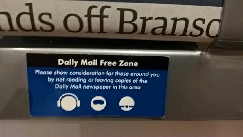
Come with a friend, and you’ll find a cosy corner to sit and chat while your coffee or tea is made. If you’re alone, there’s a decent selection of newspapers to read. This is a Daily Mail free zone.
There, I’ve gone and made myself nostalgic for another of their fine espressos. Time to plan the next visit.
Photo challenge: ‘It’s not this time of year without…..’. It’s holidays and celebrations that WordPress seems to have in mind in setting this challenge, but this is November, and we don’t do Thanksgiving in England. We do dark nights that begin at four o’clock. We do gusting rain that snatches the remaining leaves from the trees. We do fog that rises from the river. Nothing much to celebrate at all. Except …. except that it can turn out differently.
Read on.
Sunshine after rain at Studley Royal
I was in a bad mood when I got up. My shoulder hurt – a lot. The sky was steel-grey, the temperature steel-cold, and I was supposed to be leading a walk. This was going to be No Fun At All, because although no rain was forecast, we’d had two days of full-on deluge. I just knew that virtually the entire circuit would be a mud-bath.
I trudged off to our rendez-vous with ill grace. Once there though, I started to cheer up. The prospect of good company for the day is always a positive start. We set off. The ground was unexpectedly firm, the clouds started to lift and the sun to shine. Soon we were making a coffee-stop outside 14th century Markenfield Hall.
Coffee stop in front of Markenfield Hall.
Then it was through woods and across open fields (still no mud) to find a lunch spot overlooking Fountains Abbey, still framed with russet Autumn leaves.
Sandwiches, sunshine and Fountains Abbey.
After lunch, a muddy farm, where we attracted the interest of the locals.
Calves closely inspected us as we squelched past. Yes, this farmyard was very muddy indeed.
And an uplifting final couple of miles, with grazing red deer, light-reflecting ponds and surrounded by a final burst of Autumn colour.
Here is the parkland of Studley Royal. Can you see the red deer in the distance?
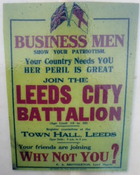
At the outbreak of the First World War, a top-level decision was made to recruit men to the Army by encouraging friends, neighbours and colleagues to volunteer together as locals, to fight shoulder to shoulder for the honour of Britain and the credit of their home town.
The men of Leeds answered the call. Carpenters, foundrymen, businessmen, men from the crowded streets of back-to-backs, men from the suburbs all joined up, bringing with them their brothers, their cousins, their neighbours and the men who worked alongside them .
They became the 15th Batallion of the West Yorkshire Regiment, commonly known as the Leeds Pals.
And they were sent up here to Colsterdale to train. There was a whole village waiting for them: a village that had been hastily built at the turn of the century to house the workers who’d been hired to construct the Colsterdale and Leighton Reservoirs, together with their families. At Breary Banks there were huts, shops, chapels – everything they needed for day-to-day life. Although the Colsterdale Reservoir had been abandoned in 1911, workers were still employed at Leighton and at first labourers and soldiers lived side-by-side.
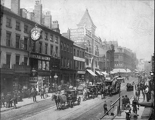
Briggate Leeds in the early 1900s (Leodis.net)
Leeds was a vast industrial conurbation. It was noisy, dirty, grimy, smoggy. Trams and those new-fangled trolley buses clanked and clattered their way round the streets. Arriving by train in Masham, the new recruits had no alternative but to march the six miles to Breary Banks, passing nothing but clean quiet villages, stock-filled fields with woodland, then heathery moorside beyond.
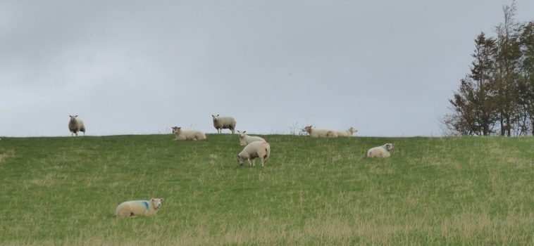
Sheep in Colsterdale
For many of these recruits, the time that they spent at Breary Banks was the best time of their lives. They had a regular routine, good food, good company and decent accommodation. They dug trenches and learned the weaponry skills it was thought they’d need when finally deployed in France.
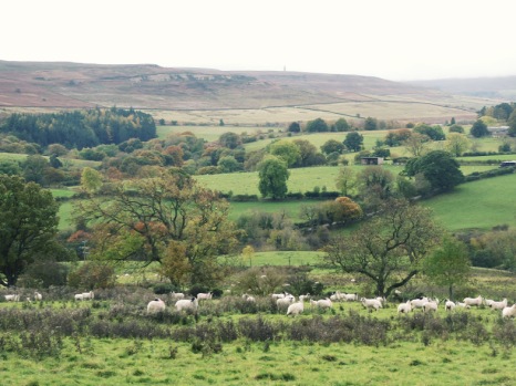
Colsterdale
In fact they first saw active service in 1915 and 1916 in Egypt and Gallipolli. Few of them were involved in direct action, and by early 1916, most of them embarked on troopships to the real focus of the war, France.
After further training behind the lines they were sent to the front, in readiness for the battle that was intended to change Allied fortunes, the Battle of the Somme.
And that is when parents, children, neighbours and work mates left behind in Leeds discovered what a truly terrible idea it had been to send whole communities into the same battle at the same moment.
‘It was the most ambitious attack of the war and they were among hundreds of thousands of Allied troops massed for the battle.
Their coats were mud-sodden, their legs were protected only by the inadequate cloth wrappings of the soldier’s uniform. In their hands they clutched rifles they would never use, for in moments a storm of bullets had cut through their soft clothes and weary bodies, and they were dead.
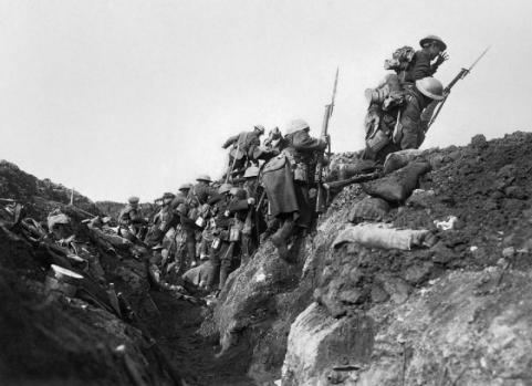
Going over the top, Battle of the Somme (Ivor Castle, Imperial War Museum, via Wikimedia Commons)
Our young Leeds men were not so much beaten as wiped out. At 7.20 am with fearful, pounding hearts, they began to run blindly at their enemy. By 7.30 am a city of mothers had lost their sons, wives were widows and children fatherless.
It was one of the bloodiest battles of the First World War. As the men surged over the top into no-man’s land they faced a murderous storm of artillery and machine gun fire directed against them with pitiless accuracy by German guns. It cut through them, they fell into the mud in waves.
Yet those in charge had expected it to be easy. In the days before the battle of the Somme, more than a million rounds had rained down on the German positions all the way along the front.
By the time it was over, the Allies believed that no-one could have survived such a bombardment. The men from Leeds, and all the places beyond, were meant to stroll across no-man’s land.
Not only did that not happen but the casualties are so great as to not really make sense. The first day’s slaughter claimed around 20,000 English and French lives, and almost 40,00 were wounded.
Yet the carnage was repeated the next day, and the next, and for every day after that until four mad months had passed.
The cost in lives has never been fully accounted, but of the more than 900 men recruited from Leeds, it is believed 750 died that day.’
Jayne Dawson, Yorkshire Evening Post, 11th November 2013
This is Private Pearson of the Leeds Pals’ own epitaph for his friends and colleagues:
‘We were two years in the making and ten minutes in the destroying.’
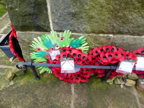
Poppies, always poppies at the foot of the memorial to Leeds Pals at Breary Banks, Colsterdale.
Back in England, it’s time to dust down our walking boots again. As we stepped out today, on a beautifully fresh and clear early Autumn morning, we contrasted our walk from nearby Masham with hikes we’d gone on in Korea.
It was the weather we noticed first. Probably it’s colder there now too, but then, we wore t shirts and battled against the humidity. We wore fleeces today. We tramped through fungus-laden woodland in both countries. Here though, as we glanced at the tussocky meadowland near the River Ure, we saw sheep, sometimes cattle . There, valley floors were terraced with paddy fields, citric green with young rice.
Here, there were distant views of solid stone barns and farmhouses – even a country house, Clifton Castle. There, we were more likely to come upon a hidden Buddhist temple, its solid, yet graceful wooden form painted cinnabar, blue-green, white, yellow and black.
In Korea, woodland in the countryside is dominant once you get away from ‘civilisation’. Here, we drifted between woods, meadows, ploughed fields and ground by the open river .
We enjoyed the lot. But today, we appreciated saying ‘hello’ again to our familiar local landscape.
Here in England, we’ve got a bit of a thing about images of a white horse cut into the hillside. There are well over 20 of them, from the South Downs to Wiltshire, via Leicestershire and even as far north as Tyneside. We like to think many of them are pretty ancient, like this one, the Uffington White Horse, first carved into the hillside chalk of Oxfordshire: probably in the Iron Age, possibly as long ago as 800 BC. But they’re not. Most of them date from the 17th, 18th and 19th centuries.
Uffington White Horse (Wikimedia Commons)
We’ve got our own white horse here in North Yorkshire, near Kilburn. It’s really rather modern. Back in 1857, a Kilburn-born man, Thomas Taylor, who’d become a provision merchant down in London thought that his home village should have its very own version of the Uffington White Horse. He got John Hodgson, who was the local schoolmaster, together with the schoolchildren and a band of volunteers to cut a horse shape from the turf to reveal the sandstone beneath. Six tons of lime were used to whiten the image, which can be seen from many vantage points in North Yorkshire, and on a clear day, from as far away as Leeds, 45 miles away, and even North Lincolnshire.
Kilburn White Horse (Wikimedia Commons)
And that’s where we went yesterday for an energetic nine mile walk. Our path took us along scenic Beacon Banks. Once it had a beacon at its summit to alert the country when danger threatened. It warned of the approach of the Spanish Armada in 1588. It was a watching point for the Home Guard during World War II. Now it’s simply a lovely place from which to survey the countryside. Our route took us past three of the prettiest villages in this part of the world – Coxwold, Husthwaite and Kilburn – through woodland, through farmland with views across to the Vale of York, the Hambleton Hills and North York Moors, passing ancient Norman churches we couldn’t call into because it was Sunday. And the White Horse – often there as a backdrop to the scenery. Here are some picture postcards of our day.
That’s where I spent my evening, near the Temple of Piety. Can’t complain at that. (geograph.org.uk)
I was volunteering at Fountains Abbey and Studley Royal yesterday evening. I wasn’t sure I wanted to be there. It was raining – and how – as I drove there, and the evening looked very unpromising.
A small team of us were there to make an evening’s Family Bike Ride round the Abbey and Studley Royal grounds run smoothly. Apparently I was going to be stuck near the Temple of Piety and Moon Ponds preventing riders from disappearing up into a woodland path, with only my two-way radio for company. I hadn’t even got an umbrella. Anyway, who would bother to turn out with their families, and all the family bikes, to trundle round Fountains Abbey in the rain?
Baby coot (Tim Felce: Airwolfhound)
I was wrong. Of course. The rain stopped. Families turned up, and lots of them. At first though, I had many minutes of peace to stand and absorb the views of the very special Georgian water garden. I spent time enjoying the company of a new family of coots: I suspect the three little spherical balls of fluff I saw with their solicitous parents had hatched that very day.
This was my view for much of the evening. Those coots are out there somewhere.
And then the bike riders came. There were confident teenagers relishing the chance to get up speed in this tranquil setting. There were primary-aged children enjoying family time with their parents. There were little ones, able to wobble along on their bikes, their parents confident that they were utterly safe from passing traffic. Open Country, a local charity working to help people with disabilities access the countryside had brought along a team and several tandems.
Some people went round the circuit once, some twice, a few as many as five times. I took lots of photos with lots of cameras for family souvenirs of the evening. Sadly, I hadn’t brought my own camera. These not-at-all impressive photos are taken with my camera phone.
I’ll volunteer again sometime for this event. But not next time. Next time I’ll want to be there with my own family, trundling around this very special site with my own grandchilden (first though, I’ll have to learn not to fall off a bike).
One of the last families of the evening finishes the last lap.
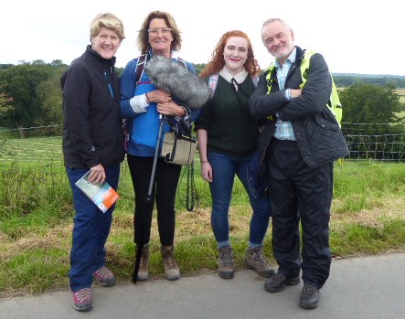
Clare, Lucy, Helen and Robert pose for a group photo. None of us asked for selfies-with-Clare
I came in the other day to find a message on the answer phone. The BBC. Clare Balding wanted to talk to me. Well, not Clare actually. She’s one of Britain’s favourite broadcasters and a bit busy I dare say. Her research assistant Lucy finally got hold of me, and asked me if I’d be able to lead Clare and team on a walk from Ripon to Ripley for ‘Ramblings’, a popular programme on BBC R4 about walking.
Why me? Because I’m Hon. Sec. of Ripon Ramblers, our local walking group, and our details are out there, if you care to look. Yes, but why ME? Lucy thought, after our chat, that I’d be OK on the radio.
OK then, why Ripon? Because, it turns out that in October 1936 the Jarrow Marchers walked from Jarrow, through Ripon to Ripley and beyond, all 280 miles to London. In October, ‘Ramblings’ plans to broadcast a programme to celebrate its 60th anniversary.
Perhaps you don’t know much about the Jarrow March. Neither did I. Not till I met Clare and Lucy, cultural historian Robert Colls, and Helen Antrobus, who’s a real Ellen Wilkinson enthusiast from the People’s Museum in Manchester. The five us walked and talked our way along our eight mile route from Ripon to Ripley, and we barely noticed the rain which threatened constantly, but only delivered occasional short sharp showers.
This is a blog in two parts. The first is our country walk, the second about the Jarrow March. But Friday wasn’t in two parts. Every step we took, we remembered those marchers. Robert and Helen told us the story. Together, we drew comparisons between their march and our own hike.
I’d already dutifully planned and walked a route. The marchers went entirely on main roads, but if you’ve ever driven on the A61, you’ll know this is no longer a good idea. Country paths were the way to go.
‘Do we go this way?’ Lucy records Clare getting directions.
As we set out together from Ripon, we got our instructions. Lucy had her furry-muff-on-a-stick. You’ll have seen those, as reporters rove round town centres talking to likely passers-by about some event that’s happened locally. When recording, Clare’s always on the right of the person she’s talking to, and Lucy’s there on the left with her recording gear. It was slightly odd to walk alongside Clare as she formally introduced to the programme, telling listeners where she was, why she was there, and who we all were. But soon we forgot about that muff. We all chatted together easily, about that March, about walking, about each other. Sometimes we had to repeat what we’d said, in a spontaneous ‘I’ve just thought of this’ kind of way, because some passing noise – RAF jets overhead for instance – had ruined the recording.
This was the scenery of the early part of the walk.
In many ways our walk was a scam. The A61 passes through rolling hillsides, productive farmland, cows in the pasture, and pretty villages. It’s all bucolic England at its best. Our route presented a more hidden countryside. Isolated farmhouses with dilapidated barn roofs, ancient pastures, secret dark, damp woodlands, and tiny rather remote hamlets.
If it survives the cut, you’ll hear Clare painting a word-portrait of this farmhouse during the programmme.
At first though, we were on a road. Badly maintained, rather narrow and with tall hedges it’s a bridle path these days, but it is still tarmacced, and perhaps the kind of highway those marchers would have recognised. Later, on grass-trodden pathways, we passed Markenfield Hall, a 14th century moated country house.
We saw Markenfield Hall nearby as we walked. The Jarrow marchers didn’t.
Those marchers didn’t. We went through the village of Markington. Apparently the marchers were welcomed here too, though we couldn’t imagine why. It’s more than a mile or so from the main road and history doesn’t record why exactly they made a detour. We strode along the edges of barley fields, on woodland paths and across gorsey heath, all without meeting a soul. Not what the marchers experienced.
This is farming country.
And we talked. That’s what I’ll remember most. The sheer pleasure of walking and talking with a group of people thrust together for the day who quickly found themselves to be friends – just for a day. Thanks you Clare, Lucy, Robert and Helen for a very special occasion. It was a real privilege.
Clare strides away into the woods.
And the Jarrow March? More about that in my next post.
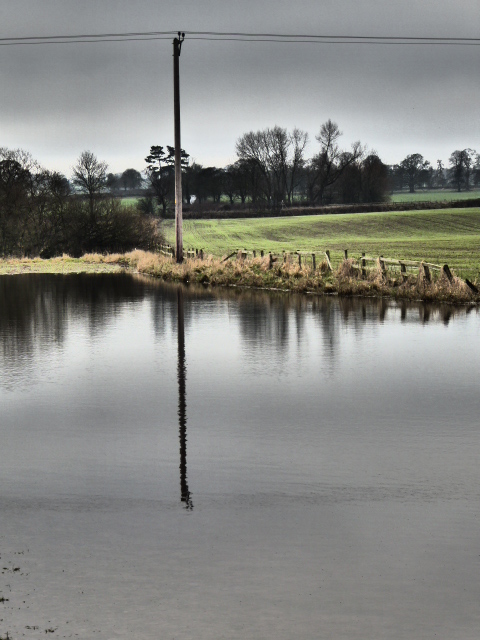
Look. Here was the scene in the field near our house, in January this year. Fields and roads flooded, impassable pathways, rocks and earth tumbling into the River Ure.
Near Old Sleningford, January 2016.
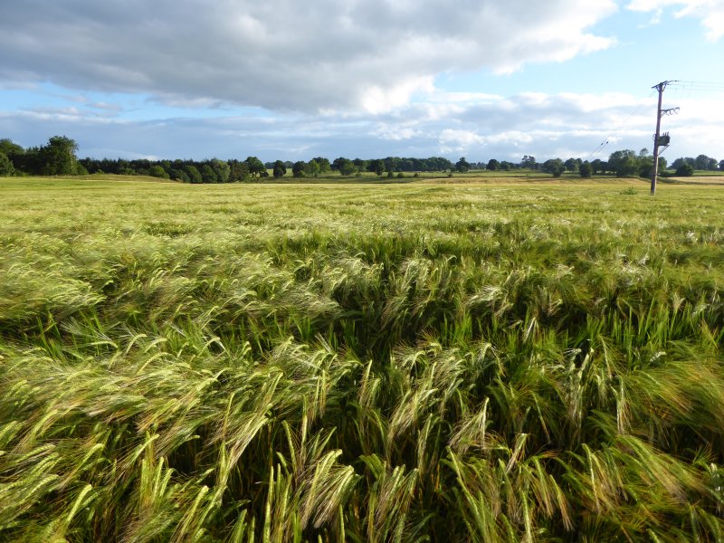
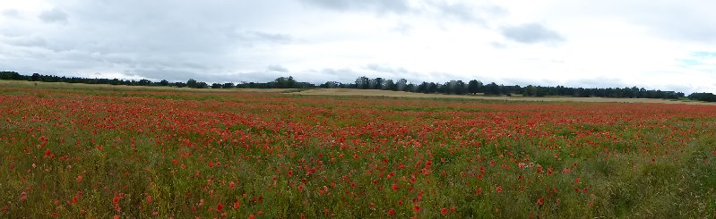
This was the same field yesterday. Barley, barley everywhere, all fattening up nicely for the harvest. Nearby, fields of poppies. Really hopeful, cheery sights on a sunny and blustery day.
The same field, July 2016
Will all our present political crises end so well? I wish I could feel more optimistic.
We went for a walk from Leighton Reservoir this week. It’s in many ways a bleak, bare, sometimes boggy landscape, and this suited our mood in a bleak, bare post-Brexit week. The view is softened at the edges by the rolling, green, stone wall-skirted Yorkshire Dales which lie beyond the heathery moors.
But look what we found as we consulted our Ordnance Survey map. These were the places we passed, or could see at a distance:
Sourmire Moor
Gollinglith
Baldcar Head
Jenny Twigg and her daughter Tib (Two natural stone stacks towering out of this boggy moorland landscape. We didn’t get as near to them as we’d have liked this time)
Grewelthorpe Moor
Benjy Guide
Sievey Hill
Horse Helks
Cat Hole
Jenny Twigg and her daughter Tib (Wikimedia Commons)
Really, where else could we be but Yorkshire?
Postscript: Just at the end we met this little chap, a just-fledged thrush. We hope he (she?)’s ok, because he just about managed to fly rather stumblingly off to a safer place than the track where we spotted him.
 On Christmas day I posted a scene from our days living in the Ariège. I felt very nostalgic for the Pyrenees, for snowy peaks silhouetted against clear blue skies, for cold clear air.


You must be logged in to post a comment.