Travel Between the Pages …. You Couldn’t Make It Up is a blog that always produces interesting, thought provoking, or just plain amusing content, This post fascinated me by showing the way in which our world map is in a state of constant flux. As it may be again …
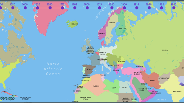
With the tragic news unfolding daily in Europe, it’s an appropriate time to take stock of how we got here. I’ve always found that maps can be an excellent way to help visualize geo-political conflicts. I recently discovered this simple, but elegant website that allows users to see exactly how borders have shifted over the decades.
Historic Borders colorfully helps to visualize the seemingly arbitrary nature of national borders and how politics and war have reshaped the world. The app features a basic world map topped by a timeline slider. Just click on a date to discover the national boundaries of that time.


Interesting stuff!
LikeLiked by 1 person
I think so. Especially those parts of the world we haven’t given maybe so much thought to, such as the Americas.
LikeLiked by 1 person
Exactly! I was surprised how early in the timeline it was marked. But there seems to be a gap between that and the more recent info.
Migration of people also played a major role.
LikeLiked by 1 person
I saw it too. But when will this damn thing stop, Margaret?
LikeLiked by 1 person
Oh, Jo. Not soon, evidently. It’s so depressing.
LikeLike
😦💟
LikeLike
Yes, very interesting…I used to have a Times Atlas which was effectively the print version of this in an earlier decade or two.
LikeLiked by 1 person
I wonder if you and Jude have the same volume as each other? So interesting to leaf through.
LikeLiked by 1 person
I used to have one from the 1980s, but the one we have now is the 7th Concise edition reprinted in 1999. A shame I didn’t hang on to the older one as it would have been very different, but it is such a big book to keep carting around!
LikeLike
Oh? Didn’t know Jude had one
LikeLike
I love maps. I still have a Times Atlas and we were looking at it recently. The early 20th century maps are very interesting. So much has changed. Not necessarily for the good.
LikeLiked by 3 people
Quite. And good old printed maps seem to be outdated almost before they’re published. But I do love a big old fashioned atlas.
LikeLiked by 2 people
As a child I always wanted a world globe! Just looking at all the countries in Africa would have kept me busy.
LikeLiked by 1 person
And let’s not even discuss the shifting Ridings of Yorkshire!
LikeLiked by 3 people
Ah, now you ARE in disputed territory!
LikeLiked by 3 people
….and who stole Westmorland?
LikeLiked by 2 people
Well, and Cumberland too, no? Rutland got itself back didn’t it?
LikeLiked by 2 people
I think it was all a conspiracy by Dr Beeching when he’d finished with the railways!
LikeLiked by 1 person
Man cannot stay away from conflict nor tinkering with boundaries 😦
LikeLiked by 1 person
Indeed. It’s interesting how some areas seem far less stable than others.
LikeLiked by 1 person
A sign perhaps boundaries were forced on one side at some point in history 🤔 or that some leaders can never settle for what they have
LikeLiked by 1 person
Interesting. Thanks for sharing. Maggie
LikeLiked by 2 people
I thought it was worth giving a wider audience to.
LikeLiked by 2 people
Yes, maps and their changes are fascinating. I should think the Finns are pretty worried about the future. This horror all seems so 20th century, why can’t we learn and be better than this?
LikeLiked by 2 people
For those of us not lusting after power and influence, it’s pretty incomprehensible. We never have learnt from the past, have we?
LikeLiked by 2 people
No we have not. So much scientific advancement and yet so little taming of the rogues.
LikeLiked by 2 people
We will never learn. But maps are interesting…
LikeLiked by 2 people
Yes – endlessly fascinating in what they reveal.
LikeLike
It was the colours of the school atlas maps that made me yearn to travel.
I was in Yorkshire last week, I looked out for you but didn’t see you.
LikeLiked by 2 people
We’ve been isolating all week with Covid, that’s why 😦
LikeLiked by 1 person
Hope you are ok.
LikeLiked by 2 people
Yeah, sort of, thanks. It’s dragging on a bit but we’re not terribly ill.
LikeLiked by 1 person
Most interesting to follow the changes on the map thanks. But it all looks so bloodless on the maps.
I have seen in the comments that you have been isolating with Covid – I assume that this is both of you? So sorry that you have been suffering this but relieved that you say that you have not been terribly ill. I hope that you both feel recovered soon,
LikeLiked by 2 people
Yes, maps really can’t convey the human side of the story – but I suppose it’s a start. Yup, Covid it is, but do-able. It’s dragging on a bit though. Bored now ….
LikeLiked by 2 people
Take it easy, and I hope you will be feeling better soon and able to be out and about again before too long, but I should think it is important not to rush it!
LikeLiked by 2 people
Well, negative now and feeling OK. But as everyone warned me, tiredness lingers … and how!
LikeLiked by 2 people
So sorry – I suppose its best to rest as much as possible while recovering rather than try to push yourself too soon. I hope that at least you are able to concentrate on a good book, even if only for short stretches at a time. Sending best wishes.
LikeLiked by 2 people
Thank you. Yes, I’m reading a library’s worth of books!
LikeLiked by 2 people
I am happy to hear that at least you have the energy to read. Take care.
LikeLiked by 2 people
Reading’s the easy option. Thanks!
LikeLiked by 2 people
👍
LikeLiked by 1 person
Very interesting, and out of date already for Crimea. So sad that we always have people who will do anything to increase their own power (or at least their view of their own power)
LikeLiked by 2 people
Indeed. And if on=line mapping gets out of date so quickly, is there any hope for a good old bound atlas?
LikeLiked by 1 person